
Hiking Mt. Amos: One Of The Best Views in Freycinet National Park
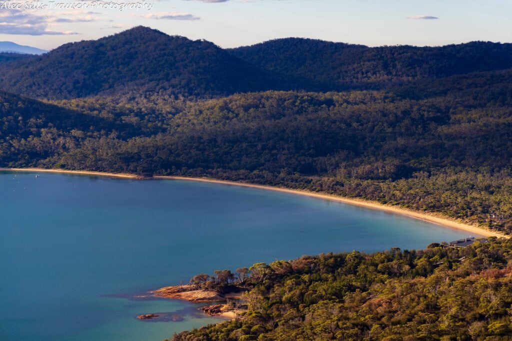
Coming across the Pacific Ocean to Tasmania, I wasn’t sure what sort of views I’d find here. But holy smokes, I was blown away! The Mt. Amos hike was our introduction to Freycinet National Park, and the views at the top, with Wineglass Bay 1500 feet below, were outstanding.
If you’re considering coming to this part of Tasmania, you HAVE to do this hike. It’s absolutely epic!
This guide explains the Mt. Amos hike, includes epic shots of the scenery, and gives you some more ideas for what to do in the area. Cheers, and happy trails!
Hiking Guide for Mt. Amos Above Tasmania’s Wineglass Bay
Mt. Amos Trail Stats
- Distance: 3.1 miles (5km)
- Elevation Gain: 1,500 feet
- Time on Trail: 3-5 hours
- Difficulty: Challenging
- Do not hike during or immediately after a rainstorm
Mt. Amos Hike Trail Report from Freycinet National Park
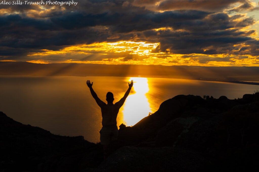
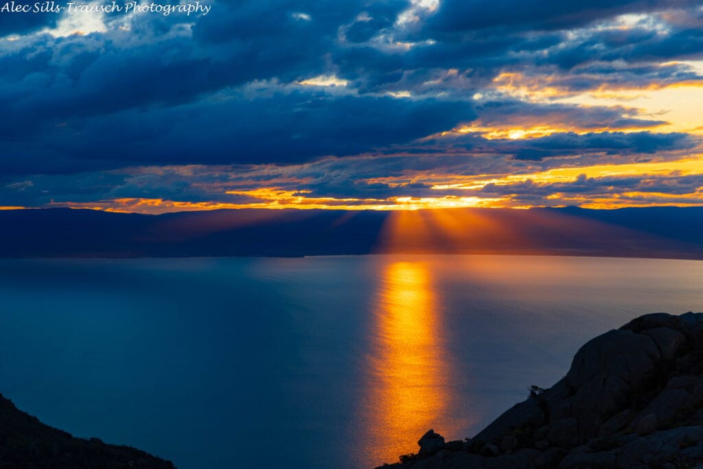
My brother and I started up the Mt. Amos trail in the late afternoon with a mission to watch the sunset from the top. As we began the slow trek up, we passed a handful of hikers coming down. I wondered if we’d be the only people at the top.
The first quarter of the hike is a pretty gentle warm-up on a dirt trail. After driving from Cradle Mountain all day, stretching my legs was nice. But not too long after “warming up,” the steady uphill section began, kickstarting our heart rates as our legs let out an annoyed sigh.

For most of this trail, you’re hiking on granite, which makes it imperative not to hike during rain, or it’ll be extremely slow-moving and dangerous. But as you keep climbing higher and higher on Mt. Amos, the views of Honeymoon Bay and Coles Bay become better and better. This gives you a perfect excuse to stop and take in the views.
Throughout the hike, keep an eye on the yellow arrows. These will be your guides for the entirety of the trail. They’re almost impossible to miss going up and down.
Once you near the top, you’ll be tired, but the views – oh, those sweet views – will give you the energy to push on.

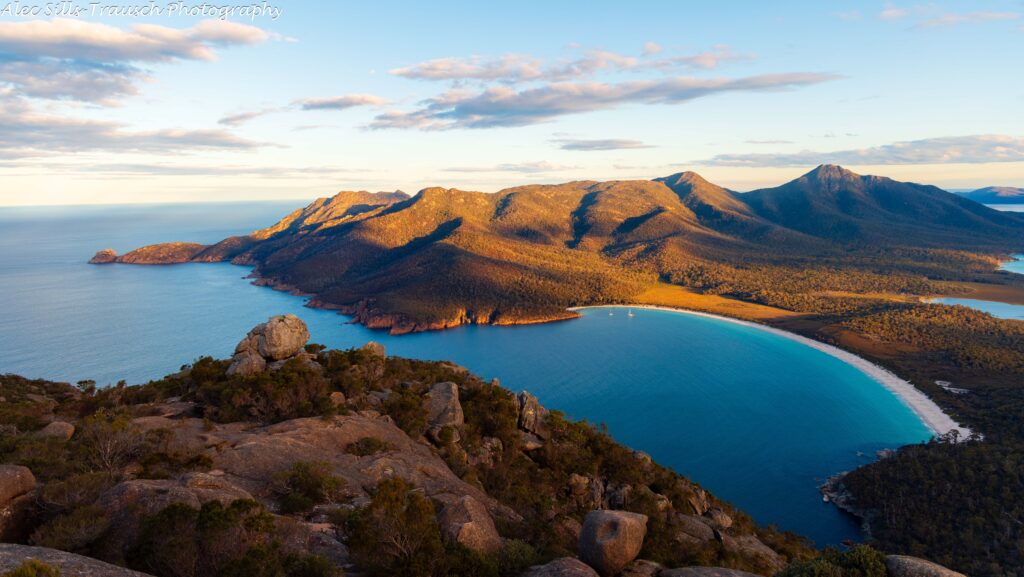
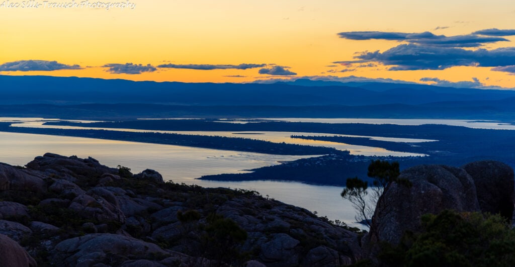
And once there, it’s stunning! We were indeed the only people on top of Mt. Amos and had some of the best views I’ve ever laid eyes on. I think the two of us were up there for a solid 45 minutes to an hour, watching the sun fade below the horizon before we packed up our camera gear, flipped on headlamps, and headed down the mountain.
What You Need To Know For Hiking Mt. Amos in Tasmania
How long does it take to climb Mt Amos?
The official signs say it should take you between three and five hours. It took my brother and me an hour up and a little under an hour down. But we spent another hour at the top, taking photos and soaking up the views.
Is Mount Amos hard?
This is a pretty strenuous hike, considering it’s nearly entirely up, and you’re using hands and feet for a good chunk of it. I was sweating bullets and breathing hard for 98% of the hike, but I’m in pretty good shape.
While the elevation gain over the short distance is challenging, being on a slick surface was the most difficult and made it very slow going. Take your time, be careful, and you’ll get up just fine!
Do Not Hike in Inclement Weather
A large portion of this trail is on slick granite rocks that, during a rainstorm, would be challenging at best and deadly at worst. If there’s any chance of it raining, stay away from this hike. Even in dry conditions, there were plenty of times when I momentarily had my feet slide and lose some traction.
So, before you head out on your Mt. Amos hike, check the weather and play it safe if it looks questionable.
Where do I start the Mt Amos hike?
Follow Freycinet Rd into Freycinet National Park, past Freycinet Lodge and Honeymoon Bay, until you hit the parking lot. You really can’t miss it! Here’s the parking lot link.

Do you need a pass for Freycinet National Park?
Yes, you do. All visitors to National Parks in Tasmania need a park pass. We bought a two-month pass because we visited a handful of parks over a weeklong period. Ours cost us $80, though there are cheaper options for a shorter time period.
What camera gear should you bring?
A 24-70 or a 24-105 should be all you need for this hike. Because the bay is so wide, there’s no need for a zoomed-in shot, so save the weight in your back and travel lightly with only a single lens.
I brought a tripod but didn’t use it. If you have a friend coming, they might be able to get shots of you, and there’s no need for the tripod.
Where Should I Stay Near Mt. Amos?
If you’re looking for lodging near Mt. Amos and Freycinet National Park, Coles Bay and the surrounding area are your best bet. The area is nice, though small, so I would book your travel in advance if you plan to explore during the busy season.
I visited in mid-April, which is entering into the quiet season, so the town was a little more subdued than I anticipated it usually is. We also stayed at the Freycinet Lodge, which is super nice and much more affordable in the offseason (about 50% less) than peak season.
If you’re looking for a solid spot that’s not in the town, this a good place to hang out.
FAQ: Exploring Freycinet National Park
Are there bathrooms and water at the trailhead?
Yes, both of these are at the trailhead. Make sure to bring at least one liter of water for your hike – if not more if it’s warm out.
Any good places to eat?
We only had two meals in the area. The first was at Freycinet Lodge’s bar section (so not the nice restaurant). We found it pretty affordable, considering a steak was $36 Australian, which is about $24 US, and you don’t have to tip!
Secondly, we stopped by The Ice Creamery, which served delicious fish and chips and some of the most amazing sweet potato fries I have ever had.
What else is there to do in the area?
There are few things to do that are worth it!
First, if you’re up for another hike, do the Wineglass Bay Lookout or hike down to the beach. It’s not easy-easy, but it’s easier than Mt. Amos. We did the entire hike in 1:50 minutes, and it was around four miles in all.

Just a heads up, the portion going down to the beach is basically like being on a stair stepper. There are 1,000 steps in all, and you’ll feel it! But it’s stunning, and I even saw a wallaby on the white sand beach.
Secondly, book a kayaking trip to see the bay, cool off, and see some wildlife! We saw Australian Fur Seals and White Bellied Sea Eagles. We didn’t see any sting rays, though they do see them when the water is clear and calm.
Another cool thing to do would be the Wineglass Bay Cruise. This is another way to get onto the water and see the sights. I didn’t do this, but it looks like a great time!
Lastly, take in the sights from the air by booking a helicopter flight over Freycinet National Park and Wineglass Bay. I wish they were running trips when I was here because this would have been amazing.
Final Thoughts on the Mt. Amos Hike
The views from Mt. Amos are some of the best Tasmania offers. While the Mt. Amos hike is challenging, it’s not terrible, nor is it reserved just for experienced hikers. Just make sure to take your time and enjoy the views of Freycinet National Park.
Once you’re at the top, with your eyes locked on Wineglass Bay, you won’t want to come down!
Until next time, adventurers, take care and be safe.
Follow on social media: TikTok || Instagram || Facebook || Newsletter