
Four-Day Mariposa and Yosemite National Park Itinerary
Growing up, one of my favorite places to explore was Yosemite National Park. Its glacially carved valley, towering spires, and magical waterfalls leave me mesmerized. It’s a place I wish everyone got to visit. However, I know that planning a trip like this can be challenging and overwhelming.
Which is why I created this four-day Mariposa-Yosemite itinerary. I hope it inspires you to plan a phenomenal trip and take the worry away from not knowing where to go.
Inside, you’ll find top-tier hiking, great views, historically significant museums, and great places to eat and stay. In all, it’s a perfect roadmap for your upcoming road trip.
Four-Day Itinerary Exploring Mariposa and Yosemite National Park
One-minute breakdown of my Mariposa-Yosemite Itinerary:
- Day 1: Travel to Mariposa, Explore Downtown, and Visit the Mariposa History Museum
- Day 2: Flightseeing over Yosemite, Yosemite Climbing Museum, Drive the Golden Highway, hike Stockton Creek Reservoir
- Day 3: Hiking in Yosemite National Park: Old Inspiration Point, Lower Yosemite Falls, Illilouette Falls
- Day 4: Hang out at Tenaya Lodge, Hiking in Mariposa Grove of Giant Sequoias, Fly Home
Day 1 in Mariposa – Exploring Downtown

I landed in Fresno and seamlessly got into my rental car at the Fresno Airport. And boom, the Mariposa-Yosemite road trip had begun! It’s a route I’ve driven countless times, and it was nice to go back.
The drive was pretty easy, about an hour and a half to Mariposa.
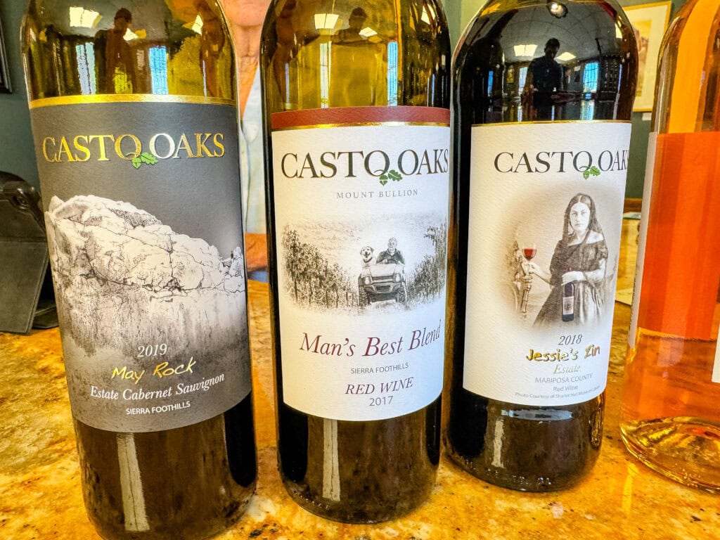
Here, I grabbed some food at High Country Health Foods (it’s a grocery store that also serves A+ sandwiches). I then headed downtown to explore some shops (the Mariposa Artist Gallery is worthwhile) and go wine tasting.
I stopped by Casto Oak Wine and had the chance to meet Kris, one of the owners. She gave a great rundown of their winemaking and the history of how they acquired the winery. The wines were fantastic, with my favorite being the Cabernet Sauvignon.
Mariposa History Museum
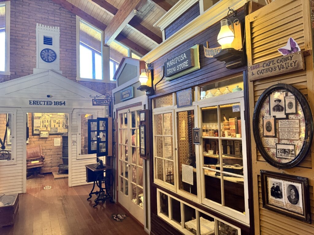
After some tasty wines, I headed up a few blocks to the Mariposa History Museum. It covers the start of the Gold Rush and how Mariposa played a pivotal role in the 1850s. They close at 4pm, so I only had a short amount of time to check it out. However, from what I saw, it’s comprehensive, going into great detail and showcasing numerous relics.
For dinner that evening, I grabbed a beer and a delicious smashburger at The Grove House. I timed it right where the local band was practicing and enjoyed lovely live music.
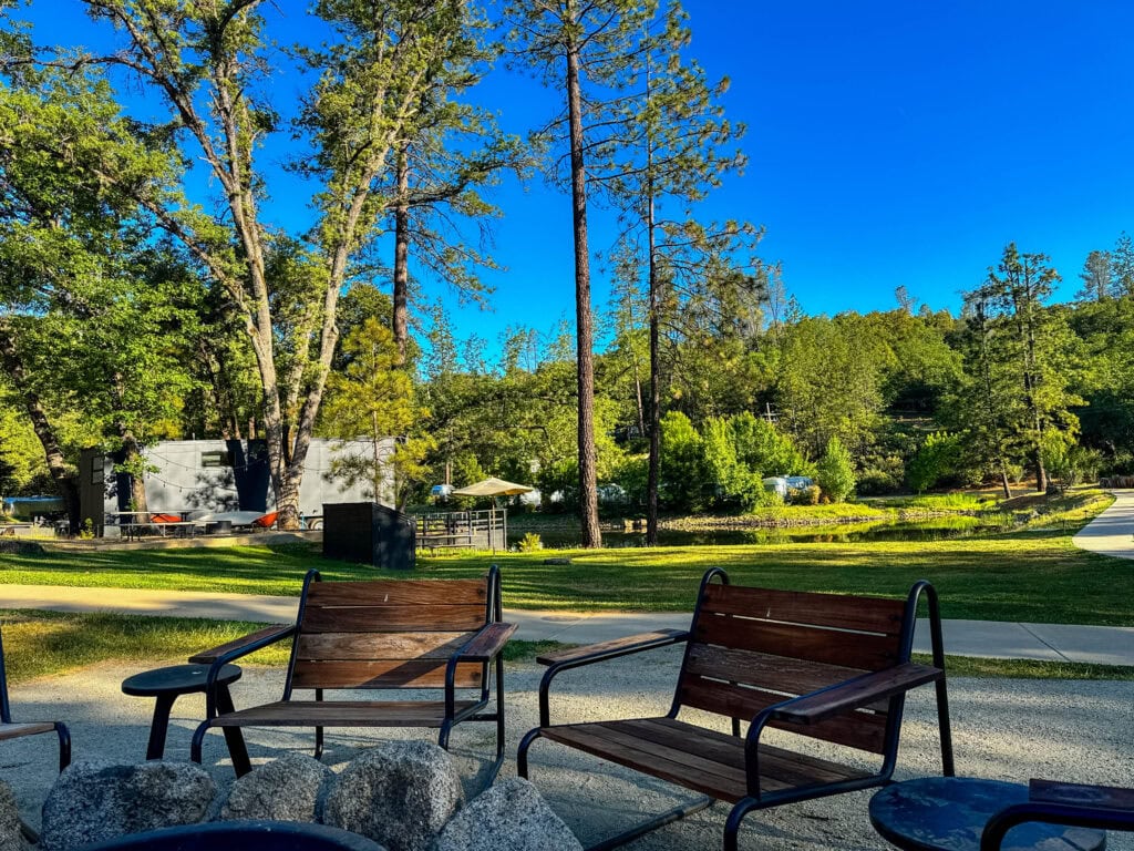
AutoCamp Yosemite
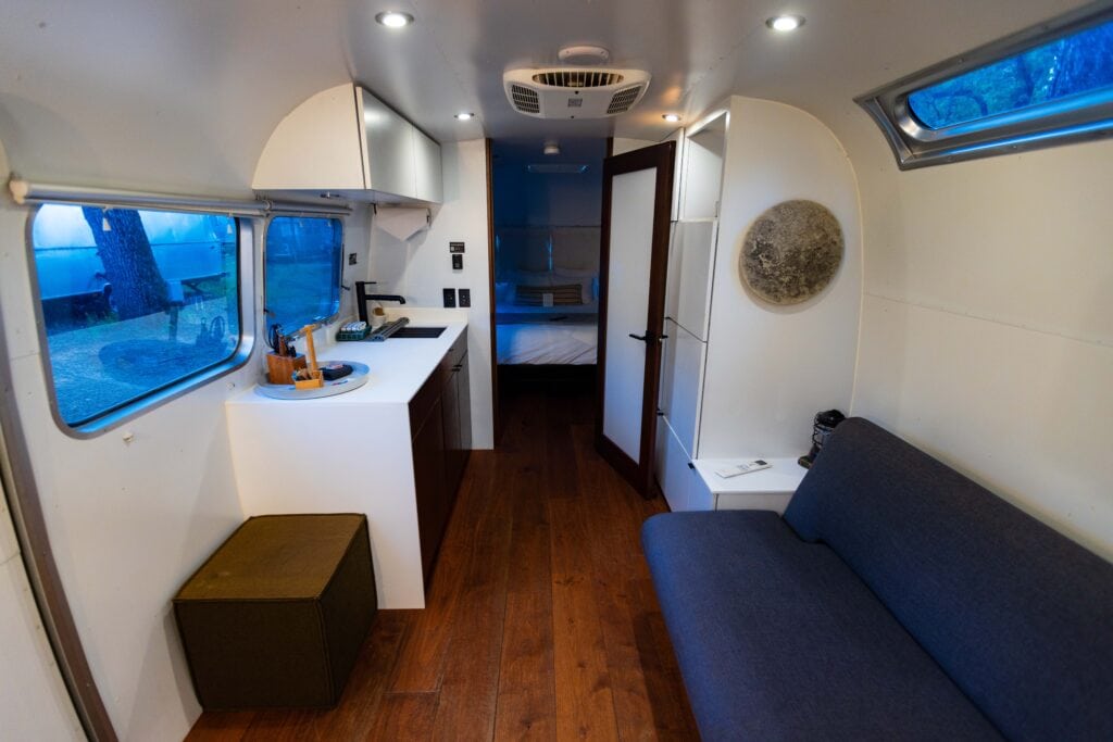


As the sun began to fade, I started the 15-minute drive to AutoCamp Yosemite. It’s tucked far enough out of town that cell service is limited (great for disconnecting, though there is WiFi), and the setup blew me away. I’ve heard of AutoCamp for years, but this was my first time staying there.
There might be 100 Airstreams on the property, featuring a great lodge area for socializing (beer and food available), as well as a pond that creates an intimate atmosphere.
My two-night stay here was nothing short of fantastic. I highly recommend it to anyone on their four-day Mariposa itinerary.
- Where I slept: AutoCamp Yosemite
- Where I ate: High Country Health Foods (lunch), Castro Oaks Wine, and The Grove House (dinner)
Easy Booking: Expedia.com | Hotels.com | VRBO | Booking.com
Need Gear: Find Gear at REI
Find Awesome Tours: Viator.com or GetYourGuide.com
Follow on Instagram: @Alecoutside
Iceland on your bucket list? Get my Iceland guide + 144 pinned locations on Google Map
Day 2 in Mariposa – Flightseeing and Golden Highway
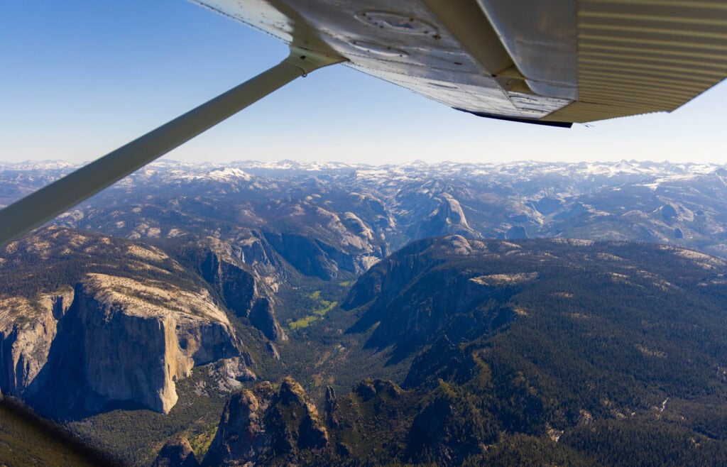
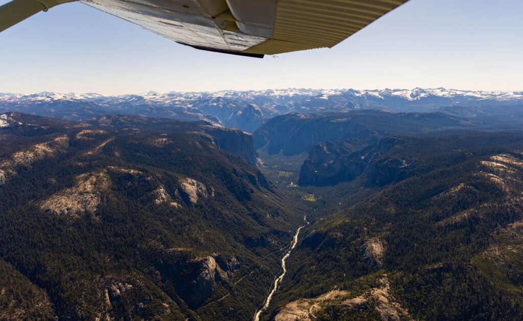
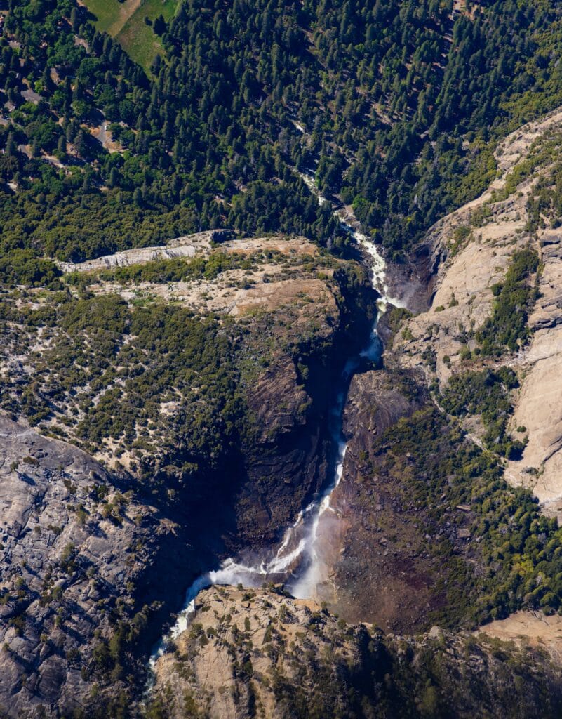
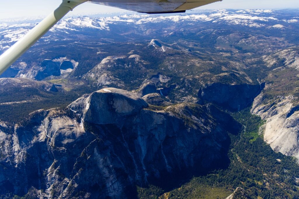
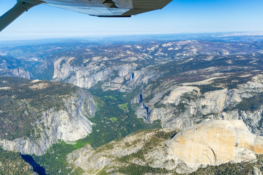
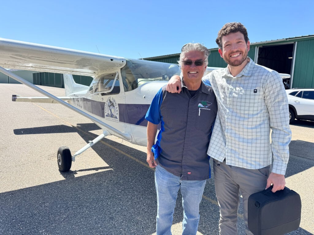
My first full day in Mariposa was a treat! I got to do something I’m not sure many people know is possible: Flightseeing over Yosemite National Park!
Just a few minutes outside of Mariposa is the airport. With safety checks complete, we jumped into the plane, and minutes later, we were airborne. The plane slowly gained elevation as we circled downtown Mariposa. From here, we followed the Merced River to the mouth of Yosemite Valley.
If you book an hour-long flightseeing trip, this is as far as you’ll go. (Mariposa airport offers the closest access to Yosemite of any town in the area.) For us, we had a chartered flight, which meant we could create our unique route. This allowed our plane to see more of Yosemite National Park’s intricate features, including Half Dome, Yosemite Falls, the Mist Trail, and so much more!
It was absolutely incredible and a bucket-list moment for me!


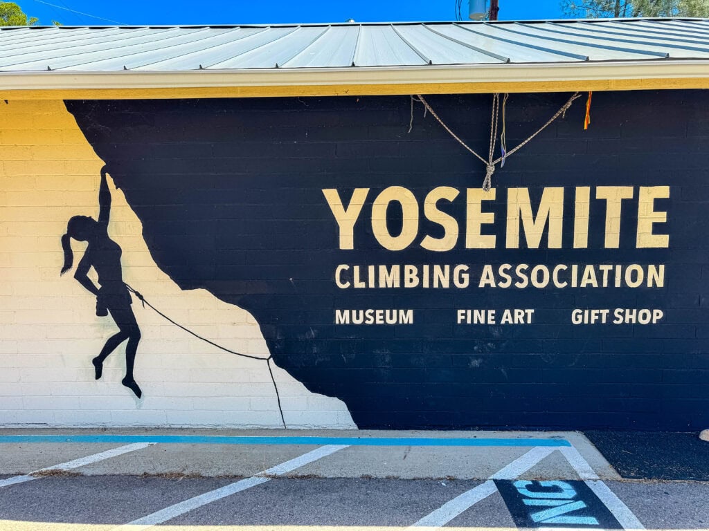
Yosemite Climbing Museum
After the flight, I grabbed breakfast at Sticks Coffee and headed over to the Yosemite Climbing Museum for a tour with local legend Ken Yager.
He and the Yosemite Climbing Association have collected an incredible array of historical climbing artifacts throughout Yosemite’s history. Hearing Ken walk through climbing in the area and how gear evolved was one of my favorite parts of the Mariposa-Yosemite Itinerary. (If you want a documentary, check out Valley Uprising on either Amazon Prime Video or Peacock.)
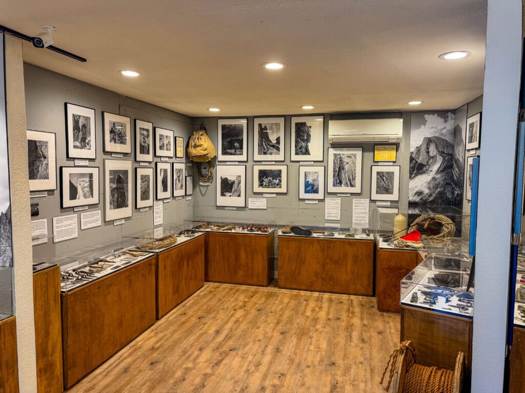
The museum is small, but it packs a serious punch and should be on everyone’s list of things to do in the area. You likely won’t need more than an hour. But no Mariposa itinerary is complete without a trip here, so make sure you give yourself time to fit it in!
Golden Highway
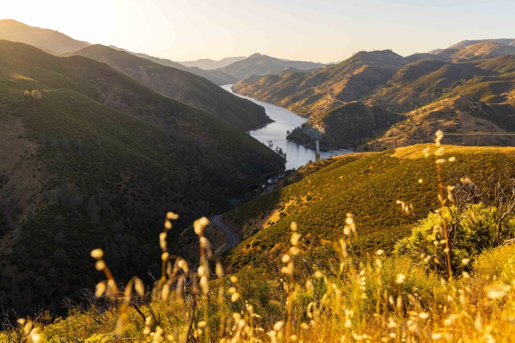
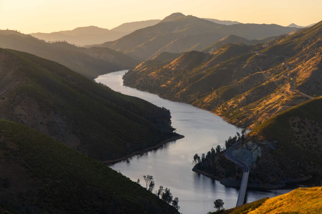

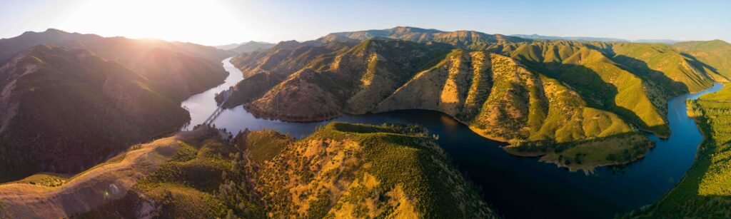
Post lunch, I drove down to Bagby Recreation area and Lake McClure to check out the Golden Highway. (I’d come back later for sunset.) This drive is incredibly scenic, but it’s also very winding, so be prepared to go slow. The best time to visit is in April, when the wildflowers are in bloom. Unfortunately, I missed it by a few weeks.
Stockton Creek Reservoir
Around 4pm, I headed to Stokton Creek Reservoir. Everyone in town told me it was a nice walk, so I figured, why not check it out! And they were correct! Just a few minutes out of town, up by the high school, you feel like you’re entirely in nature.
The birds were chirping, the grasses rustling, and the sound of water flowing could be heard below. Just keep an eye out for rattlesnakes. One crossed the trail mere feet from me – talk about a little adrenaline rush to begin the hike!
I took the lower route and then hiked up the crossover section to reach the water. In all, I hiked around three miles.
Photo tips for flightseeing:
- Lens in the range of 24-105 or 70-200, depending on the type of photos you want (wider viewpoint will get the airplane wings)
- Set the shutter speed at least 1/1000 (or higher, depending on light), aperture in the 5.6-8.0 range, and then fill in the gap with ISO (or put it on AUTO, but keep an eye on it so it doesn’t go above 1,000)
- Where I slept: AutoCamp Yosemite
- Where I ate: Sticks Coffee (breakfast), High Country Health Foods (lunch), and Little Shop of Ramen (dinner)
Day 3 in Yosemite National Park – Hiking in the Valley

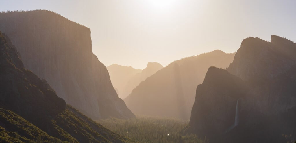
This was a full-day, nearly sunrise-to-sunset, hiking adventure throughout Yosemite Valley. I awoke before sunrise and drove an hour to Tunnel View along the winding Merced River. There were a handful of photographers there enjoying the end of golden hour. But I had my sights set on something new.
(Author’s note: I don’t necessarily expect anyone to follow this hiking day completely. But if you do, you’ll have a fantastic, albeit tiring day!)
Pohono Trail

I started up the trail behind Tunnel View on the Pohono Trail (also called Artist Point Trail, Stanford Trail, and Inspiration Point Trail). As you ascend, you’ll enjoy some breathtaking views of the valley without the crowds.
As I headed to Old Inspiration Point, the climb steepened and my pace slowed. Overall, I did 2,600 vertical feet in 3.5 miles. But the best part is that I saw three people all morning.
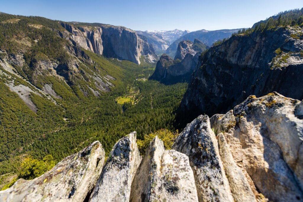
Once I left the forest and descended to the edge of the cliff, the magnificent Yosemite Valley came into view. I was all alone, in a park that sees over four million visitors a year. With El Cap, Bridal Veil Falls, Half Dome, Ribbon Falls, and Silver Strand Falls all in view, it was an All-Star lineup of striking landscapes.
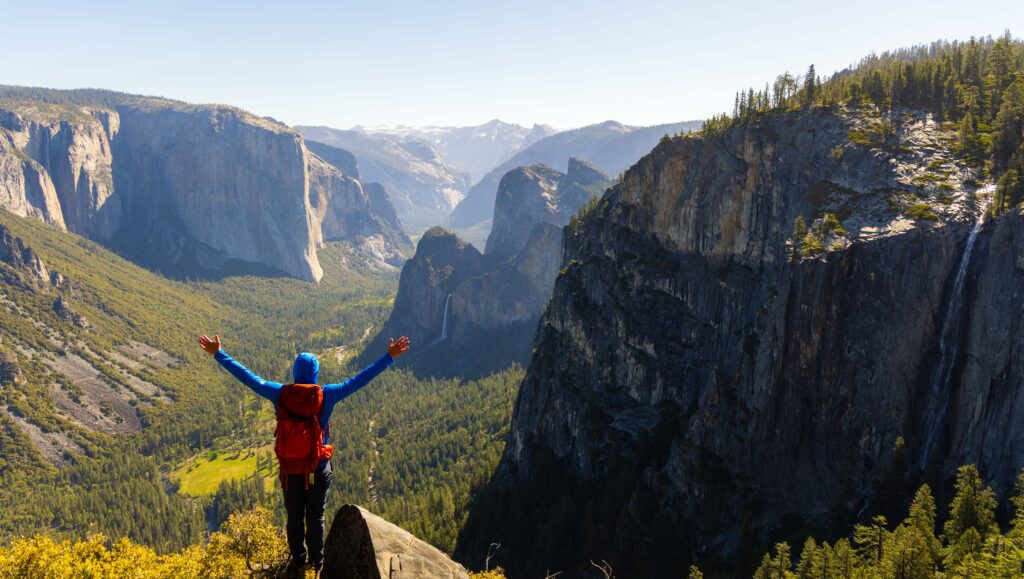
For the next hour, I took photos, enjoyed the views, and explored different viewpoints. As the temperatures started to rise, I began my descent to the valley floor. I didn’t see a soul for 98% of it until I met a couple who hiked up 100 yards from Tunnel View to escape the tour buses and heavy crowds.
Yosemite Valley
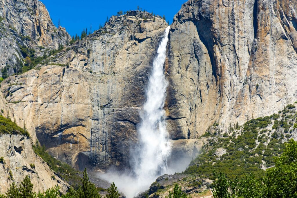
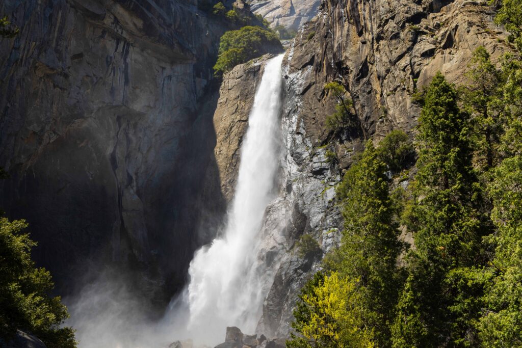
I drove down into the valley, stopping once to take in the views of Yosemite Falls from across the meadows. Next, I wanted to head into the Ansel Adams gallery. Unfortunately, there was literally no parking available. After circling parking lots for 15 minutes, I headed to Yosemite Valley Lodge for lunch and to do the short walk up to the base of Lower Yosemite Falls.
In late May, the snowmelt is so fierce that you’ll feel the cooler temperatures halfway down the paved walkway. And once you reach the base, hold onto your hats. The intensity of the waterfalls is one of my favorite parts about spring in Yosemite.
After cooling off, I began the drive up to Glacier Point. Depending on traffic, this is anywhere from 50 50-minute to an hour and a half drive. Thankfully, at this time of day, it was the former.
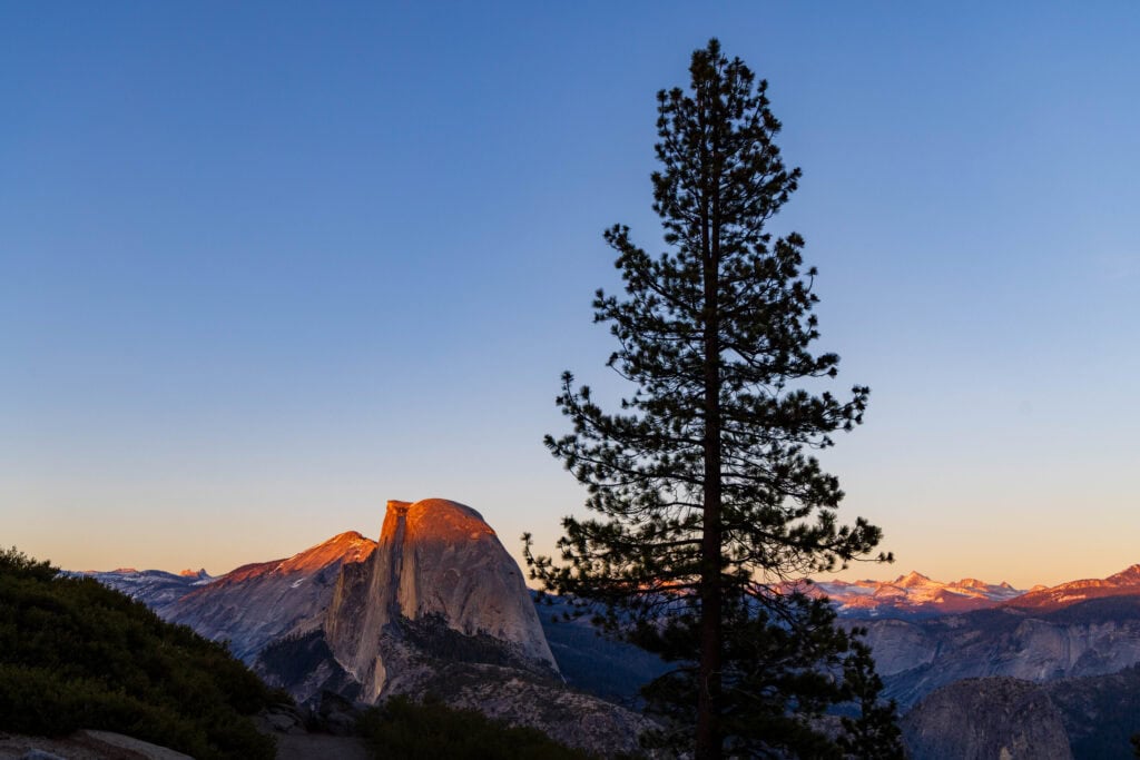
Glacier Point and Illilouette Falls

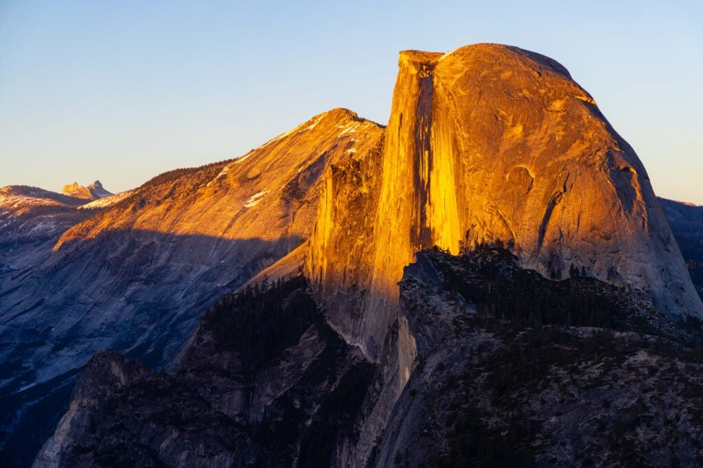
Glacier Point is one of my favorite locations in Yosemite National Park. It’s incredible for sunrise or sunset, and a few thousand feet off the floor, it’s much cooler. To wrap up my day, I wanted to do a new hike: Illilouette Falls. I’d heard good things, and I couldn’t pass up another waterfall adventure.
This hike is one of the easiest in the park. At 4.5 miles and 1,400 feet of gain, it’s a mild descent to the falls with Half Dome looming in the distance. With a 5pm start, I saw six people on the trail. Talk about solitude!
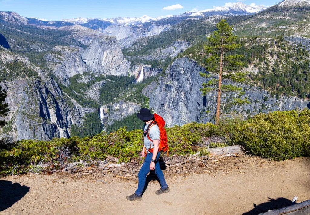

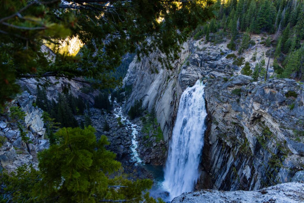
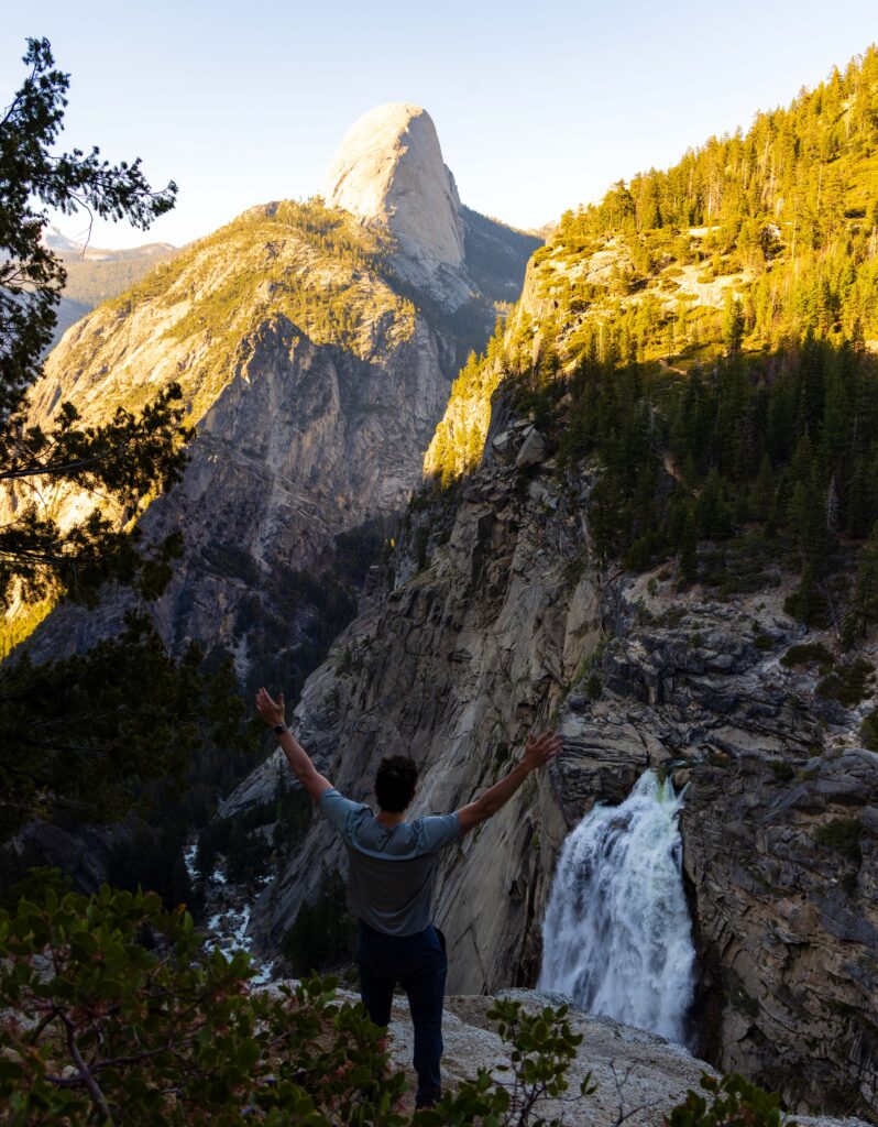
For almost the entirety of the trail, you have Half Dome and Vernal and Nevada Falls in view. Only at the very end does Illilouette Falls emerge. There’s a short trail down to a better viewpoint. But please be careful. It’s slippery, and going to the edge is dangerous.
I made quick work hiking back up to Glacier Point and enjoyed the sunset. It’s one of my favorite places to photograph, as you get to watch the light rise up the sheer western face of Half Dome.
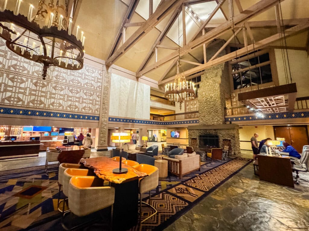
With 13-14 miles under my belt, I was exhausted but thrilled. It had been a gorgeous day in Yosemite, and my adventure cup was filled to the brim! Now, it was time to drive the 75 minutes to Tenaya Lodge and grab some food.
- Where I slept: Tenaya Lodge
- Where I ate: Yosemite Lodge Food Court (lunch) and Tenaya Lodge @ Jackalope’s Bar and Grill (dinner)
- Hiking Highlights: Old Inspiration Point, Lower Yosemite Falls, Glacier Point, and Illilouette Falls
Day 4 in Yosemite National Park – Giant Sequoias at Mariposa Grove
My final day of the four-day Mariposa-Yosemite road trip was a little slower.
After 14 miles the day before, the legs were tired, and I needed some sleep. So, I listened to my body, had a slower morning, and enjoyed the delicious breakfast buffet at Tenaya Lodge.
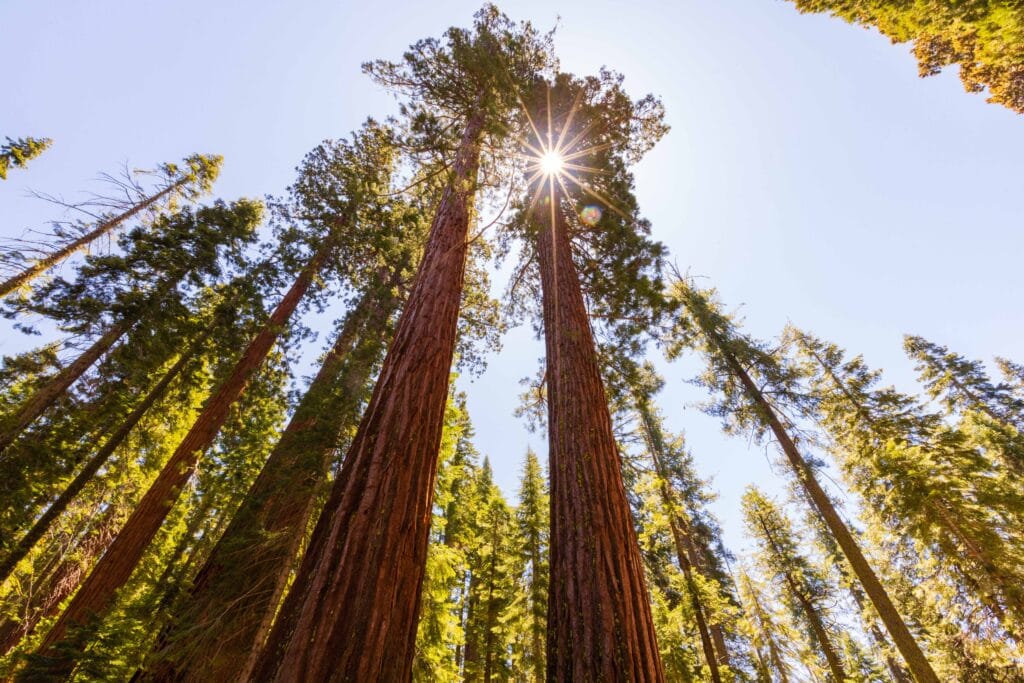
With a full belly, I walked around the lodge a bit before packing up and heading back into the park to explore the Mariposa Grove of Giant Sequoias. I thought I hadn’t been there, but after chatting with my mom, I learned I had visited sometime as a child.
Still, this was my first time as an adult visiting, and it was fun to check out a new area of a park I’ve seen so much of.
One thing to know about the Mariposa Grove is that you cannot physically drive to the big trees unless you have a disabled parking pass. Right after entering from the southern entrance, go right at the roundabout and park at the information center. Here, you’ll hop onto the free shuttle, and they will take you to the start of the trail. In all, I’d estimate it to be a 10-minute drive.
As of my trip, hiking around the Mariposa Grove is limited due to ongoing construction and a recent fire.
That said, you can still hike to Grizzly Giant, the main attraction on the final day of our Mariposa-Yosemite itinerary.
Mariposa Grove – Grizzly Giant Trail
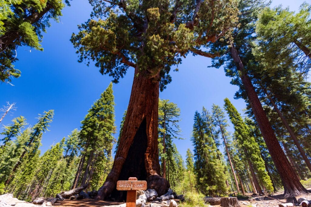
After hopping off the full bus, I started the Big Trees Loop counter-clockwise. This quarter-mile walk to the Fallen Monarch is lined with towering Giant Sequoias. From here, I continued onto the Grizzly Giant Trail to the Grizzly Giant. It’s a 0.7-mile walk with a slight incline. The halfway point, when you cross the road, will show off the Bachelor and Three Graces.
The Grizzly Giant has limbs and trunks extending from all sides, giving it a look reminiscent of something out of a Star Wars movie. I spent some time taking photos and enjoying the view. (PS: Go to the back side of the tree for more solitude.)
Instead of completing the Grizzly Giant Loop (the park ranger suggested it didn’t have many views), I returned the same way and finished the second half of the Big Trees Loop. In all, I did around 1.5 miles.
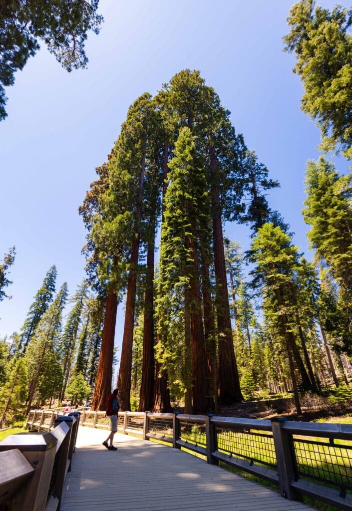

As someone who loves Sequoia National Park, getting to spend some time in the presence of Giant Sequoias is always a treat to be had!
Photo Tips:
- A wide-angle lens to capture as much of the trees as possible
- Polarizer to increase vibrancy
- Use humans as scale to show tree size
Where I ate: Tenaya Lodge (Breakfast Buffet and grab ‘n’ go lunch)
Lodging Options near Mariposa and Yosemite
Where to stay near Mariposa
Here are a few places I recommend staying.
Budget-Friendly: Quality Inn Yosemite | Yosemite Inn | Monarch Inn
Mid-Level: AutoCamp Yosemite | Best Western Plus

Where to stay in/around Yosemite National Park
Here are a few places I recommend staying.
Budget-Friendly: Cedar Lodge
Mid-Level: Yosemite View Lodge | Curry Village | Yosemite Valley Lodge
Luxury: Tenaya Lodge | The Ahwahnee | Rush Creek

Planning to camp? Click here for Yosemite Camping Information
Travel Tips for Visiting Mariposa and Yosemite
What are the best months to visit?
One of the great aspects of this area is that it is accessible year-round, meaning your Mariposa-Yosemite itinerary can happen whenever! That said, I recommend the springtime. The temperatures are still mild in Mariposa, and you’ll have roaring waterfalls throughout Yosemite Valley just like I did. It’s honestly one of the most magnificent places to be in the United States.
Remember, Yosemite National Park has timed entry permits
In 2025, the timed entry permits for Yosemite National Park are back in effect. But they’re a bit complicated. Here’s the information straight from the NPS:
A reservation will be required to drive into or through Yosemite National Park on some days from May 24 through September 1, 2025, for those driving into the park between 6 am and 2 pm as follows:
- Through May 23: A reservation is not required at any time.
- May 24 through May 26 (Memorial Day weekend): A reservation is required from 6 am to 2 pm on Saturday through Monday.
- May 27 through June 14: A reservation is not required at any time.
- June 15 through August 15: A reservation is required from 6 am to 2 pm every day.
- August 16 through August 29: A reservation is not required at any time.
- August 30 through September 1 (Labor Day weekend): A reservation is required from 6 am to 2 pm on Saturday through Monday.
- September 2 through the rest of 2025: A reservation is not required at any time.
Driving through the park will also require a reservation if entering between 6 am and 2 pm. If you are planning to visit after peak hours, please do not arrive before 2 pm; vehicles blocking roads will be cited.
Purchase an America the Beautiful Pass.
How to get to Mariposa?
Getting to Mariposa is incredibly easy from Fresno International Airport. Hop on the 41 and take it north to Oakhurst. From here, head west another 25 minutes and you’ll arrive in the cute downtown.
In all, expect it to take around 90 minutes.
Do you need to rent a car?
Yes, you’ll want to rent a car when visiting Yosemite National Park. There are ways to do it via public transit, but those will cost you time, and you’ll have a less enjoyable experience. For four days, my cost was a big over $300.
Plus, for a photographer like me who operates at weird times, relying on others to drive me early or late is not a reasonable request. Having your own car gives you great flexibility.
How far is Yosemite from Mariposa?
Mariposa is a quick 60-minute drive to the Yosemite Valley entrance on the west side of the park. I recommend getting an early start to the day to avoid traffic and lines and to maximize cooler times in the park.
One thing to note is that there is a construction stoplight at the halfway point of the drive due to a rock slide. This hopefully won’t cause too long of a backup, but it may delay your travels on your Mariposa-Yosemite itinerary.
Summer is WARM!
Even in the mountains, Yosemite Valley warms up. From June to September, it’s not uncommon for temperatures to reach the upper 80s or low 90s. This is when I suggest getting up into Tuoloumne Meadows and enjoying the high country. (Check out Cathedral Lakes, Tenaya Lake, Clouds Rest, and Lyell Canyon.)
Hiking Gear I Recommend
- Wide-brimmed hat
- Sunglasses
- Sun shirt or sun hoodie
- Hiking Shoes or Trail Runners
- Hiking Shorts or Hiking Pants
- 25L+ Hiking Pack
- 2L hiking bladder or water bottles
- Garmin inReach 2
- Garmin Fenix hiking watch
- Light jacket for mornings
- Hiking Poles
More Photos from my 4-day Mariposa-Yosemite Itinerary


Final Thoughts on Spending Time in Mariposa and Yosemite National Park
It was incredible to return to one of my favorite places in California and my second-favorite national park in the country. I’m thrilled to have had the chance to explore the town of Mariposa and learn more about its history, which dates back over 170 years.
Getting to spend four days in Mariposa and Yosemite is the perfect amount of time to see the sights and immerse yourself in the mesmerizing landscapes and incredible hiking trails. If you have Yosemite in your plans, be sure to add at least a night in Mariposa to grab some food and slow down!
Until next time, adventurers, stay safe.
Follow on social media: TikTok || Instagram || Facebook || Newsletter | YouTube