Ultimate Guide: Backpacking Titcomb Basin inside the Wind River Range
Wyoming’s Wind River Range and Titcomb Basin are the few remaining ‘hidden gems’ in the American West. It’s considered some of the best backpacking America has to offer. After spending four days and 40 miles backpacking in Titcomb Basin, I can only agree that it is in the upper echelon of best trails.
In the last five years, it’s seen its notoriety explode. Yet, due to its proximity to nothing, it still survives the influx of crowds that Mother Nature has been experiencing since the Instagram era began.
Sitting in the northwestern quadrant of Wyoming, four hours from Salt Lake City and two-and-a-half hours from Jackson, the Wind River Range is a daunting yet serene backpacking location.
The journey to Titcomb Basin is full of lakes, towering peaks, and a stunning landscape that will make you want to return again and again. Inside is my guide and everything I learned on this amazing trek.
Easy Booking: Expedia.com | Hotels.com | VRBO | Booking.com
Need Gear: Find Gear at REI
Find Awesome Tours: Viator.com or GetYourGuide.com
Follow on Instagram: @Alecoutside
Iceland on your bucket list? Get my Iceland guide + 144 pinned locations on Google Map
Your guide to Backpacking Titcomb Basin inside the Wind River Range


Where is Titcomb Basin?
Titcomb Basin is in the heart of the Wind River Range and the Bridger Wilderness in North Central Wyoming. The trailhead is about a 15-minute drive outside of Pinedale.
How hard is the Titcomb Basin trek?
It’s pretty strenuous. It’s about 12 miles to Island Lake – where we set up camp – and it’s got 2,500+ feet of elevation gain over those 12 miles. So you’re constantly going up and down, and the final lake never seems to appear.
We also had heavy packs, which undoubtedly contributed to our fatigue.
When is the best time to backpack Titcomb Basin in Wyoming?
Summer is the best time to visit Titcomb Basin and the Wind River Range. My trip happened at the end of July, and there was no snow on the standard trail. Furthermore, day and night temperatures were very reasonable.

Are bear canisters required in the Wind River Range?
Yes, you need to bring bear canisters on your Titcomb Basin trek. While I never saw one, you are in a very remote area of Wyoming with little human presence.
Are there grizzly bears in Wind River?
Yes, this is grizzly bear territory, and while I never saw them, they could appear at any time.
Practice bear awareness safety
When in the Titcomb Basin area, please practice bear awareness safety. This means you eat, sleep, and poop in three different places. By doing this, you keep smells that could attract bears away from your tent, thus protecting yourself.
What are the rules for camping near Titcomb Basin?
You must be 200 feet from both the water and the trail when backpacking Titcomb Basin. The Rangers will get on you for being too close.
Where should we stay before and after Titcomb Basin?
I can vouch for the Pinedale Hotel and Suites. I’ve stayed there twice, and it’s a lovely spot with good breakfast options and a hot tub. As we all know, having a nice place to soak after a long trek is perfect. And it’s close to the brewery!
Backpacking Titcomb Basin Key Trail Details
- Trailhead: Elkhart Trailhead outside of Pinedale, WY
- Distance: 40+ mile loop over 4 days
- Route: Elkhart Trailhead to Island Lake to Fremont Peak to Pole Creek Lakes to Elkhart Trailhead
- Starting Elevation: 9,350
- Highest Point: Fremont Peak – 13,700
- Difficulty: Very strenuous
- Permits: No Wind River backpacking permits
An Intimidating Titcomb Basin Trip into the Wind River Range
If you only glanced at the roller coasting-looking route, it’d be hard to fault you for thinking this is barely a challenging hike to Titcomb Basin. Yet, you’d be wrong by a matter of galaxies.
Starting at over 9,300 feet, the trailhead is higher than 37 other states’ highest points, immediately presenting an already challenging hiking environment. Luckily, the trail is pretty consistent, albeit roller-coaster-like, regarding elevation gain – nothing too steep until you start your summit of Fremont Peak. For the trail quality, it’s very lovely and well-maintained (we even saw people doing trail repairs on our way out).
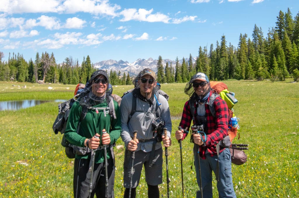
Overall, our Titomb Basin backpacking trip was my most desolate backpacking experience. We saw maybe 20 people all trip, most of whom were kids doing the trail maintenance. This was exactly what we wanted. A proper nature trip away from people and technology.

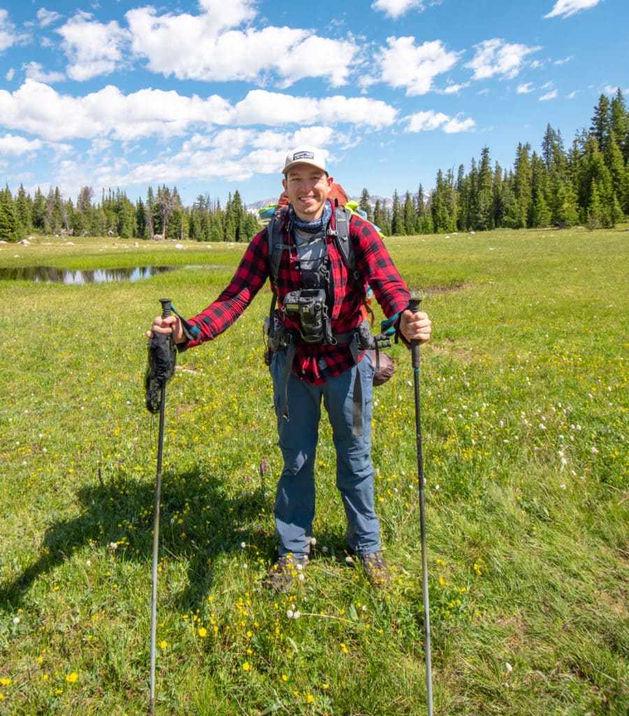
The gear I brought backpacking Titcomb Basin
- Gregory 65L backpack
- Big Agnes Tent, Sleeping Bag, Sleeping Pad
- Jet Boil and Fuel
- Six freeze-dried meals (three breakfasts, three dinners)
- Snack Food: Trail Mix, Dried Fruit, Electrolyte Gummies, bars, prepacked chicken and salmon, beef jerky
- Camera, three lenses, tripod (Read my blog on backpacking with a camera)
- Hiking Poles
- Lowa Boots
- Trash bags
- Mosquito repellant
- Headlamps
- Shovel
- 3 Socks
- Down Jacket
- Buff
- Wool long sleeve
- Beanie
- 2 Pairs of Pants
- 2 Leggings
- Three hiking shirts
- Wind Jacket and rain jacket
- Sunglasses
- Hat
- Bug net
- Gravity Water Filtration System
- Lightweight Chair
Day 1: Elkhart Trailhead to Island Lake – 12 miles
The sky was gray, and a slight drizzle was falling from the sky as the three of us headed into the Wind River Range toward Titcomb Basin. With a starting point of over 9,300 feet, we immediately felt the elevation. None of us live above 1,100 feet above sea level, so this 9x increase was rough.
Less than a mile in, we had to stop to drop layers, which meant the chance of getting eaten alive by mosquitoes increased dramatically. So this is what life is like while in the Wind River Range.
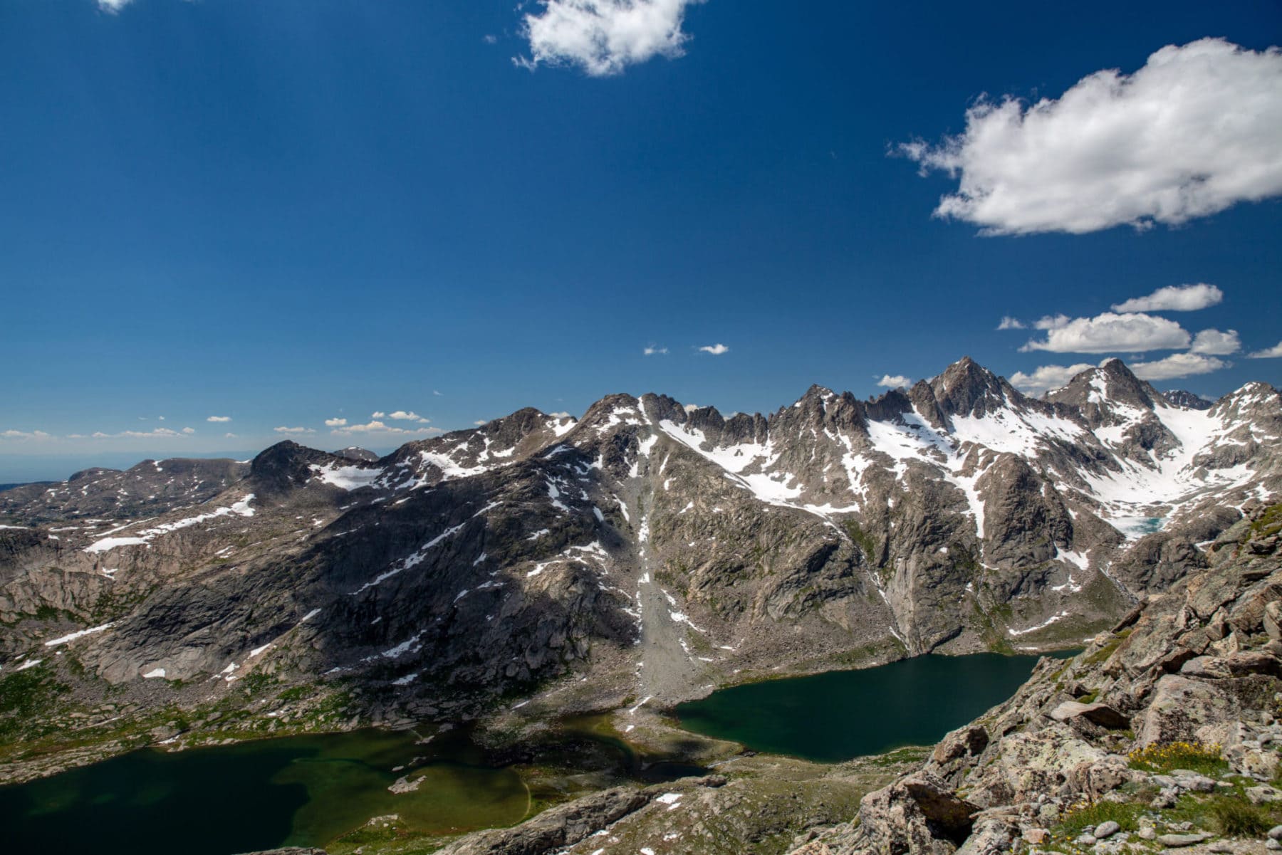
Throughout the next 11 miles to Island Lake, we trekked through several backbreaking and soul-crushing, lake-filled valleys as we got closer to our final destination. The stunning views kept morale high, though.
In all, it took us around 5 hours to get to Island Lake – we only took two breaks along the way (primarily due to the unbearable number of mosquitos).


Along the way, we were constantly amazed by the beauty surrounding us. Perfect reflections. Hidden valleys. Jagged peaks. My kind of paradise while Wind River backpacking.
Titcomb Basin – Island Lake Appears
Once we arrived at the pass overlooking Island Lake (I was behind due to pack complications), I let out the most exhausted yell known to humankind. We were home! After a quick walk around to the other side of the lake, we began to set up our tents and get ready for the evening.
A lovely sunset made an appearance right before a huge windstorm rolled in. The guys and I quickly grabbed our outlying gear and tossed it into our tents. The last thing we wanted was to spend the morning running around, trying to find clothes or chairs.
That night, after backpacking to Titcomb Basin, I slept like a baby.


Day 2: Island Lake to Titcomb Basin to Fremont Peak – 8 miles
We awoke and began getting ready for a beautiful day ahead. Whatever “storm” had hit us the night before was long gone, and we had a perfectly still lake with epic reflections to stare longingly at.
However, a ranger who told us we had accidentally camped too close to the water interrupted our coffee and sunrise. Oops.
This slight nuisance cost us an hour or so of our summit hike, as we had to move our camp to another location. We could have used the extra hour later in the day adventuring around Titcomb Basin.


Once we were ready, the gang packed up and headed towards Titcomb Basin, one of the most beautiful places in the Wind River Range. We only had about a mile walk to the junction, but we missed it and continued into the basin. Not a bad thing at all. It was stunning.
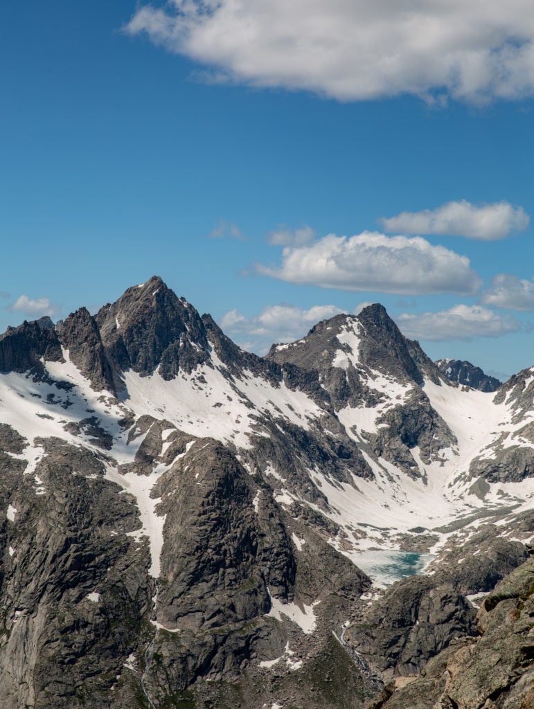
After realizing our slight error, we headed back and began our trek up towards Indian Pass, though that wasn’t our destination. Instead, we were headed to Fremont Peak, which stands at 13,700 – the third-highest peak in Wyoming.
We hit another basin filled with snow runoff before beginning our ascent. It was all gorgeous.
Summit attempt of Fremont Peak
You can take a few routes leading you to the same steep slope. The three of us decided to traverse the first lake and then jaunt over a few rocky mounds before making our way up. (That probably made no sense…but if you look at the All Trails route, we split the lakes and then went up instead of staying on the left side of the lakes.)


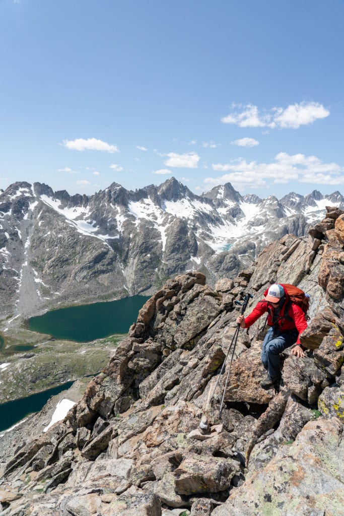
Most of the trail was without snow, but once we hit it, we strapped on our microspikes and began the strenuous trek. Once you’re hiking at over 12,000 feet, every step is exhausting. Eventually, we made it to the saddle that overlooks Titcomb Basin, and our minds were absolutely blown. It. Was. Stunning.
The gang rested, fueled up, and began climbing for the last 700 to 1,000 feet.
I’m not sure how high we got, but I’m pretty confident we got over 13,000 feet. After that, the trail got a little sketchy, but nothing I wasn’t too concerned about. Finally, however, the other two didn’t feel comfortable going forward, so we decided to pass on the summit and make our way down.
I was bummed, as I love summits and will probably not make my way back to Fremont Peak again.


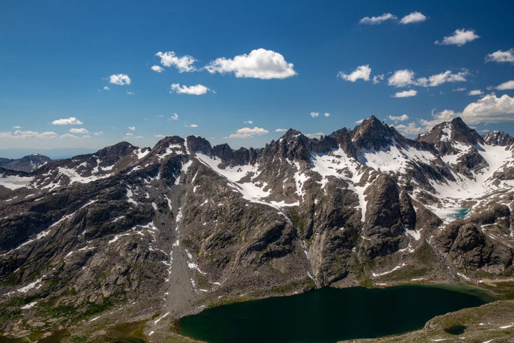

The way back was uneventful, and when we finally met up with the actual trail, we were pretty happy to have easy traveling ahead. However, we were all still in awe of seeing Titcomb Basin from above.
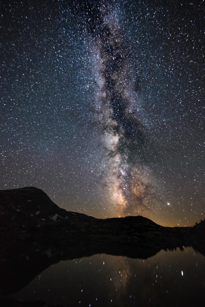
After dinner, we went to bed early as we woke up at 12:30 am to shoot the Milky Way. Quick heads up before you see the photos below, it was the most spectacular Milky Way I’ve ever seen. The sky was clear and had no light except the stars above. Thank god for Wyoming being in the middle of nowhere. It’s another huge pro for Wind River backpacking.
Milky Way in Wyoming

Day 3: Island Lake over Lester Pass to Pole Creek Lakes – 9 miles
Our original idea was to make the big loop around Wall Lake and then make our way home (as seen on AllTrails). We decided that morning to take a little more direct approach home – but one that would take us onto the Continental Divide Trail. We’d have to go up and over Lester Pass at 11,500.
Again, this doesn’t seem too rough as Island Lake was at ten thousand and change, but we lost elevation leaving the lake and then had to gain it back and then some. It’s safe to say we were plenty bonkered once we reached the pass and indulged in a significant amount of food.
At this point, I was feeling sluggish. I hadn’t eaten much breakfast, which showed, considering I was last up. But, at this point, I scarfed down a boatload of food (yes, we get scientific on this blog…) and felt so much better after the fact.
We made good time heading down and even ran into some CDTers. I, as usual, stopped to chat. After that, our next stop was when we had to cross a 50-yard-wide river. This meant we had to take off our shoes. Luckily, my Packems were just perfect for this occasion. Unfortunately, the other two weren’t as lucky and struggled walking barefoot.
Fast forward another mile or so, and we had to cross another river. This is where it got interesting. And when I mean interesting, I mean hilarious when looking back at it. As Ben crossed the river, he lost one of his shoes. We all stared at it, not sure what to do.

Thankfully the river was relatively slow here, and Ben could eventually wade out a couple of hundred yards and get his boot. It also ended up being that the river was only a yard deep, so he didn’t even get wet.
The rest of the day was a wash. We set up camp. Ate dinner. And then got chased inside as another storm whacked us. This time it came with some crazy lightning strikes that lit up the sky. I had never been in a high-elevation thunderstorm and worried about getting hit.
Day 4: Pole Creek Lakes to Elkhart Trail Head – 9 Miles
The final day of backpacking Titcomb Basin was a bit rough. We had around 8-9 miles, and only the last half was flat or downhill.
The three of us were exhausted, my back was in bad shape after carrying over 50 pounds, and I, for one, was fed up with re-packing my backpack for the 100th time.
We started early that morning, maybe 7:30 am, and started down the trail. Moments later, we retraced our steps. We accidentally bypassed the fork in the trail, which was the correct way home.
Sadly, that wasn’t the last time we made a whoopsie when it came to staying on the trail.

After a few miles of climbing uphill, I checked the map and realized we were far off the trail. Uggh! We backtracked and made a beeline toward the path. This forced us through a swampy area that required finessing and stream jumping. Finally, we were back on the trail! Nothing like fun as we backpacked Titcomb Basin.
After that, it was smooth sailing, though it felt like we were moving through molasses.
Once we reached the parking lot, I quickly ditched my pack and probably shed a small tear.
Backpacking Titcomb Basin – Looking back
This Wind River Range backpacking trip had been brutal on my body. It showed that I hadn’t had a chance to train as well as I would have liked. However, the Wind River Range and Titcomb Basin were unique experiences and one of the best backpacking trips I’ve been on.
The scenery is exquisite. The company was fantastic. And the memories created will last a lifetime.
If you’re interested in another backpacking experience in Wyoming in the Wind River Range, check out Cirque of the Towers.
Until next time, adventurers, stay safe.
Follow on social media: TikTok || Instagram || Facebook || Newsletter | YouTube