
Backpacking Guide to Rae Lakes in Kings Canyon National Park
In Kings Canyon National Park, Rae Lakes might be the most famous lake in the entire western United States and one of the hardest to reach. Sitting on the PCT and JMT, it’s also part of the famous Rae Lakes Loop trail that starts at Roads End in Kings Canyon.
Due to its unique position, thousands of people pass along its shores each year. However, to witness the beauty of Kings Canyon backpacking, you have to be able to backpack to Rae Lakes.
Yet, even though it’s popular, routes can be soul-crushing. From Roads End, it’s about 20 miles. If you start at Onion Valley, it’s 12, but two 11,700+ passes stand in your way. From the north, even more challenging routes exist.
Easy Booking: Expedia.com | Hotels.com | VRBO | Booking.com
Need Gear: Find Gear at REI
Find Awesome Tours: Viator.com or GetYourGuide.com
Follow on Instagram: @Alecoutside
Iceland on your bucket list? Get my Iceland guide + 144 pinned locations on Google Map
How to Backpack to Rae Lakes from Onion Valley and Kearsarge Pass
While the much more popular route to backpack Rae Lakes is the Rae Lakes loop mentioned above from Roads End, I’m going to talk about a secondary route coming in from Onion Valley.
The Rae Lakes Trek – 3 Days, 30 miles, ~8000 feet of elevation gain
Now that all the red tape is behind us, let’s get to the fun part. Getting to backpack to Rae Lakes!
On paper, the route is simple. Start at Onion Valey Trailhead, crest Kearsarge Pass, hike next to a bunch of lakes in the basin, crest Glen Pass, and finally descend to Rae Lakes. Easily 12 miles, right?
Yeah, not so much. Here’s how it went day by day.
Day 1 Kings Canyon Backpacking – Onion Valley Trailhead to Rae Lakes: 12 miles, 4,500 feet of elevation gain

This day was a doozy. First, I slept at Onion Valley Campground to help acclimate myself, as it sits at 9,100 feet. (Side note: Beautiful campground, highly recommend.) Then, after waking up at 6:15, I brewed some cold instant coffee, got dressed, and made my way to the trailhead parking lot a hundred yards away. By 7:45 am, I was packed and on my way.
You climb towards the 11,700-foot Kearsarge Pass for the first five miles. It’s nothing too daunting—just a long ascent. The pass also acts as the entrance point to Kings Canyon National Park. As you begin heading west down the pass, you have entered Kings Canyon. For the next three to four miles, you’ll wind your way past Kearsarge Lakes, Bullfrog Lake, and Charlotte Lake.


I’d strongly recommend filling up your water at Bullfrog Lake, especially in the late summer, as there’s no likely water until Charlotte, which will require a detour.
Once you pass Charlotte Lake, your uphill to the nearly 12,000-foot Glen Pass begins. It’s also a long trek until the finish, where your switchbacks will steepen, and you’ll seemingly be moving up the side of the mountain at an ungodly angle. A lake just below Glen Pass is accessible if you need water. I heard secondhand this is the best-tasting water in the area.
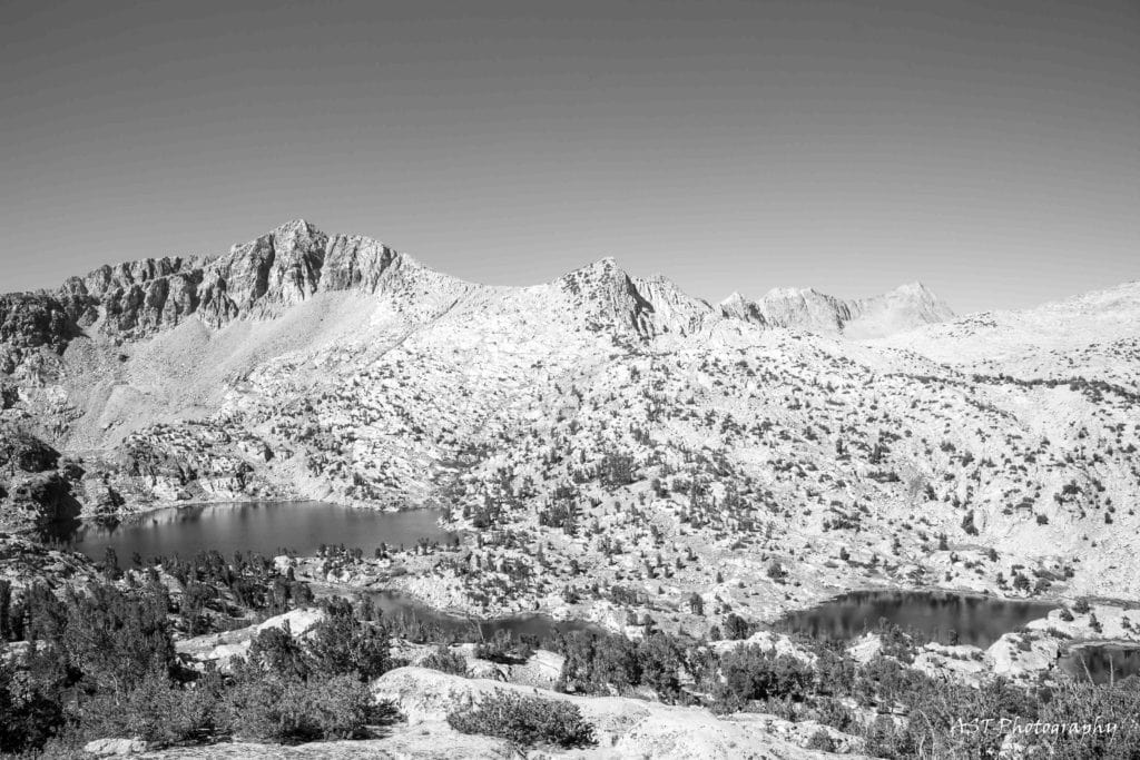
As you crest, you’ll realize this is less a pass and more a rocky ridgeline. It was super gnarly up top and finally provided a view of the Rae Lakes basin. From here, you’ll have two miles to the lakes. After a long day, these final miles are grueling.
We set up our tents just off the Sixty-Lakes Basin Trail and enjoyed watching the sunset and the stars come out. I was so dang happy to have been able to backpack to Rae Lakes.


Day 2 Backpacking Rae Lakes in Kings Canyon – Sixty Lakes Basin to Kearsarge Lakes – 9 to 10 miles
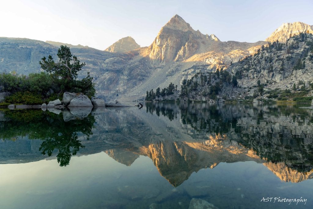
The beauty of sunrise photography in the mountains is it usually happens a bit later than in the rest of the world. So I used those extra minutes to sleep in. But once up, I ventured down to upper Rae Lakes and soaked in the stunning reflection from Painted Lady to the south. With enough photos to make a wedding photographer jealous, I headed back to camp for coffee and breakfast.
Before long, I was back on the trail, heading up to Sixty Lakes Basin. I’d only seen it on a map, but it would be stunning if the name held any weight. However, I didn’t realize it was such an uphill push from camp. The trail rose to over 11,000 feet, and I began to feel every mile of the previous day.
After arriving just above the first lake, I meandered around, trying to find a high point that would allow me views of the area. I failed but still found it to be a beautiful place. If I hadn’t been so exhausted or were staying in the basin all day, I would have continued exploring.


I had packed up before heading to the basin, so the journey up and over Glen Pass began anew once I was back at camp. By this time, it was 12:30 pm, and I was roasting in the sun. I had two miles to the pass with hardly any shade. Thankfully, I crossed a small stream and was able to soak my buff to keep my head and neck cool. This was a lifesaver.
Ninety minutes later, there I was, sitting at the top of Glen Pass, enjoying the final stunning views of Rae Lakes before taking on the last 5 miles of the day. By 4:45 pm, I was at Kearsarge Lakes, pack off and in the water, giving my body a much-needed soak.
Day 3 Backpacking Rae Lakes – 6 miles, 1,000 feet of elevation gain


This was the easiest and most stress-free day of the three in Kings Canyon National Park. With only a mile and 1,000 feet uphill to conquer, we weren’t rushing to get out. Instead, I shot photos, enjoyed two cups of coffee, and slowly packed up.
While we walked slowly, it didn’t take us more than an hour to go from the second Kearsarge Lake to the top of Kearsarge Pass. Then, after some congratulatory fist bumps, it was all downhill.
The five miles were warm, with the sun beating down, but parts of the hike had some shade. I sped down the mountain, passing uphill hikers, looking defeated in the early afternoon heat.
At 12:01 pm, I raised my arms as I passed through the imaginary finish line of the hike, thinking only of the Gatorade waiting for me. I was so stoked to get to backpack to Rae Lakes.
Planning your trip to Rae Lakes in Kings Canyon
How hard is the Rae Lakes Loop?
This is a daunting backpacking trail with over 40 miles to cover with 7,600 feet of elevation gain. Most people hike it clockwise, as it allows you to cover more elevation over a longer period of time. However, it’s incredibly beautiful, and you’ll fall in love with the Rae Lakes basin.
Is the Rae Lakes Loop clockwise or counterclockwise?
As I touched on above, I think you should go clockwise to reach Rae Lakes. This means you’ll take the Bubbs Creek route in and the Woods Creek route out. While you’ll have to crest Glenn Pass on day three with more tired legs, your pack will be lighter, which will be an incredible boost to your morale.
However, if you want to backpack to Rae Lakes and get the hardest part of the hike done early, going counter-clockwise will achieve this!
What month is best to backpack to Rae Lakes Loop?
Depending on the snowfall, July through October is the best time to hike to Rae Lakes. If it’s a low snow year, you could theoretically get to it in June. Just remember, Rae Lakes sits at 10,500 feet in elevation, which means it can still be chilly in early summer.
Get my FREE backpacking guide here

Kings Canyon Backpacking Permits
Getting permits for the Rae Lakes Loop is incredibly difficult. It may even be the most challenging permit to obtain in Kings Canyon. Due to this – and the fact I wasn’t going to do four days – I set my sights on permits for Onion Valley.
Now, snagging a permit for this location isn’t exactly easy either. It’s just easier. Going solo, I grabbed the final permit a couple of days before I went. For those wanting to plan a bit further out, you can apply for permits in February/March and also two weeks prior.
Other popular routes to Backpack Rae Lakes
The most popular route is backpacking from Roads End and either going clockwise or counterclockwise to Rae Lakes. This route is about 40 miles which is greater than the Onion Valley and Kearsarge Pass route. However, you only have one major pass to hike through.
Gear to Use Hiking to Rae Lakes via Kearsarge Pass
Backpack to Rae Lakes with this gear:
- Lightweight Tent
- Lightweight Sleeping Pad
- Warm Sleeping bag for mountain camping
- Water filter
- Satellite Communicator
- Trekking Poles
- Wool base layer to keep you dry: Men’s and Women’s
- Nice comfy fleece as a mid-layer: Men’s and Women’s
- Down Jacket for extra warmth: Men’s and Women’s
- Comfy yet durable pants: Men’s and Women’s
- Rain jacket: Men’s and Women’s
- Beanie
- Sunglasses
- Wool Socks: Men’s and Women’s
- Sturdy Hiking Shoes: Men’s and Women’s
- 50L and up backpacking packs
Need gear for your trip? Shop REI.
Final Thoughts on Backpacking Rae Lakes in Kings Canyon
- Backpacking to Rae Lakes was an incredible experience. There’s no denying the beauty, ruggedness, and effort it takes to get there. However, if you’re looking for a place just as beautiful and requiring a lot less effort, I’d recommend Big Pine Lakes.
- It’s a serious hike backpacking Rae Lakes. Regardless of the route, novices shouldn’t attempt it unless you’re with experienced hikers.
- Get a sense of the water situation along the hike. In late summer, a lot of places were dry. It’s better to fill up often than not at all.
- Camping is not allowed within 100 feet of water or the main trail. Bear canisters are required. Pack out your trash.
- Kings Canyon backpacking can be a busy trail. Uphill hikers have the right of way unless they defer.
Until next time, adventurers, stay safe.
Follow on social media: TikTok || Instagram || Facebook || Newsletter | YouTube