
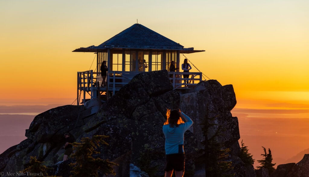
Stunning views await at the top of Mount Pilchuck Fire Lookout
If you’re looking for one of the best bang-for-your-buck hikes in Washington, the Mount Pilchuck Lookout is the hike you should take. You’ll be on cloud nine with epic views of three volcanos and plenty more stunning peaks!
I finally checked this hike off my list with the road now open, and it was even better than I ever hoped for! While challenging in parts, it was a good hike overall, and the photographer in me loved being in the middle of so many stunning views. Plus, it’s pretty close to the Seattle metro area, making it a great day hike without taking up too much time!
Below, I detail everything you need to know for the Mount Pilchuck hike, with plenty of photos to inspire your next trip!
Easy Booking: Expedia.com | Hotels.com | VRBO | Booking.com
Need Gear: Find Gear at REI
Find Awesome Tours: Viator.com or GetYourGuide.com
Follow on Instagram: @Alecoutside
Iceland on your bucket list? Get my Iceland guide + 144 pinned locations on Google Map
Hiking Guide up to Mount Pilchuck Lookout
Quick Hike Stats
- Distance: 5.5-miles round trip
- Elevation Gain: 2,143
- Difficulty: Moderately Strenuous
- Time on Trail: 2 hours 48 minutes
- Trailhead Location
- Road Quality: Good for all cars
- Views: 8/10 with three volcanoes
Mount Pilchuck Fire Lookout Trail Report
I had wanted to hike up to the Mount Pilchuck Fire Lookout for a while, but the road had been closed, and before that, I didn’t know if my Prius could make it. After some sort of road repairs and paving, it is in phenomenal shape. So, I convinced a buddy to join me for sunset, and off we went.
The first two miles are a nice warm-up. On a very well-maintained trail, we gained about 1,200 feet in all and moved pretty quickly through here, as there aren’t many views to stop for.
Then, at the 1.8-mile mark, you leave the forest and begin the rocky section that steepens and requires more focus on where to put your feet. When you look up, the tall point on your left is the top – though you can never see the actual fire lookout from below.
Over the next mile, as you hike through the saddle, you’ll gain 1,100 feet, making it slower and more challenging. But thankfully, it was only a mile. And the views at every turn get so much better.
While the trail starts you on the north side, you’ll pass through the saddle and get onto the south side of Mount Pilchuck. And once you’re on this side, the end is fast approaching!
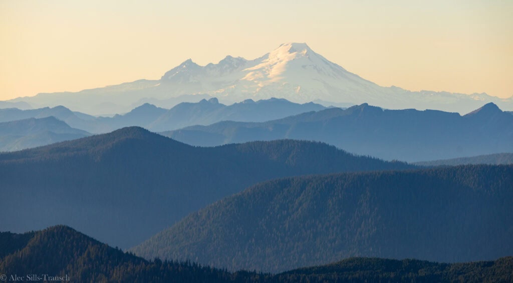
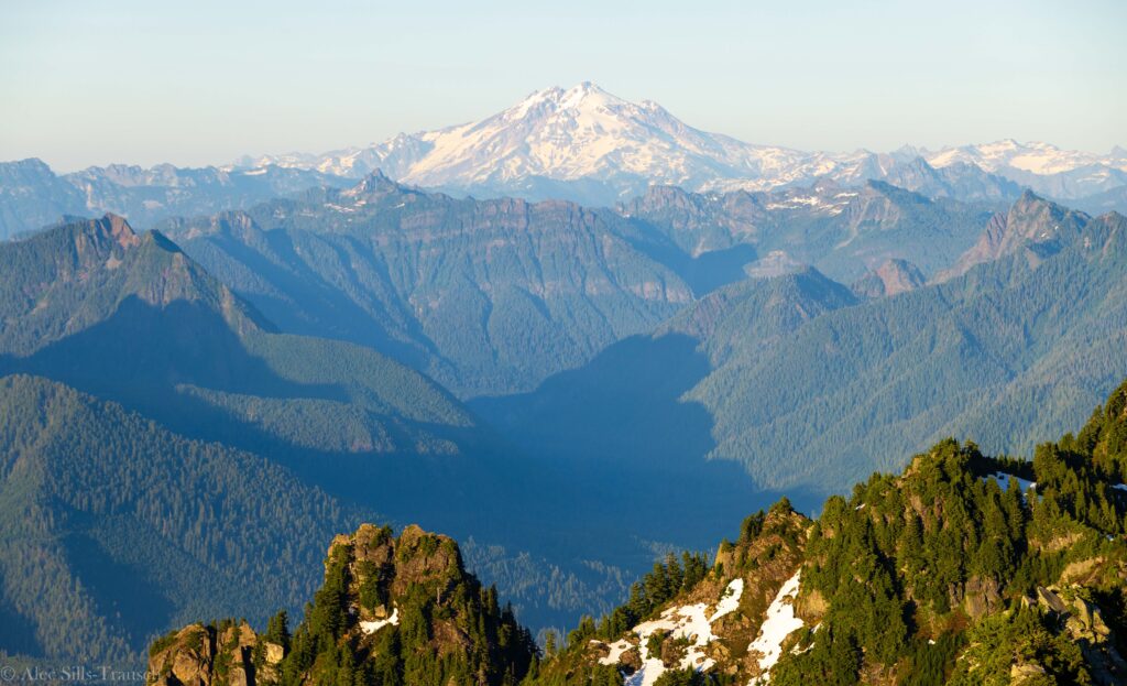
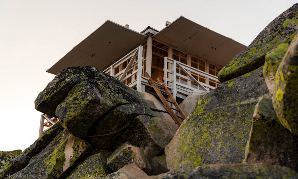
To reach the lookout, you have to scramble over 20 feet of rocks before reaching the ladder, which brings you to the top. None of this is dangerous, but it requires some careful maneuvering. Once up at the top, the views blew me away! Baker rises elegantly to the north, with Glacier Peak to the east and Mount Rainier looming large toward the south.
It’s all picture-perfect, and photographers will be in heaven up here! You can bounce a bit up top to find unique vantage points, including the actual fire lookout.
It took us 95 minutes to reach the top, and we ended up chilling there until a bit after sunset. On the way down, we shaved off 22 minutes to reach the bottom in the dark in 73.
What to know about hiking up to the Mount Pilchuck Lookout
Where is Mount Pilchuck Located
Mount Pilchuck is the first significant peak on the Mountain Loop highway, making it a perfect hike for those looking to keep their drive time down while still getting stunning views at the top. The forest road starts just past the small town of Verlot, about 90 minutes northeast of Seattle. It sits in the middle of Mount Pilchuck State Park.
Finding the Trailhead
It’s super easy to find the trailhead. Once you turn onto Forest Road 4220, follow the road all the way up for seven miles, past Heather Lake Trail, to the Mount Pilchuck Trailhead. The road has undergone substantial improvements over the last couple of years and is accessible in any vehicle.
If you go in the late afternoon, be aware that the light and dust will create terrible driving conditions, so take it slow. We almost hit a parked car near Heather Lake because we literally couldn’t see anything.
Tips for the Pilchuck Fire Lookout Hike
This one is pretty standard. The first two miles are nicely maintained and in a forest. Trail maintenance has done an amazing job building steps into the trail. The last mile or so is much more rocky as you make your way to the Mount Pilchuck Lookout.
- Keep an eye on orange markers as you go up/down
- Reaching the actual fire lookout requires minor rock scrambling. This is like 30 feet long, but you’ll be using hands and feet
- Plenty of mosquitoes
- No water at the top
- No beds inside the lookout tower
- On a clear day, you can see at least three volcanoes – Baker, Glacier, Rainier – and maybe even a fourth with Mount St. Helens
- Bring hiking poles

How long is the Mount Pilchuck hike?
It’s about 2.7 miles to the top of the Mount Pilchuck Fire Lookout, but it goes pretty quickly until the end. The last mile is where you gain about half of the elevation, and this part is much rockier, which will slow your speed down. Still, at only 5.5 miles round trip, it’s a huge bang-for-your-buck-hike.
How Hard is the hike?
It’s not a cakewalk, that’s for sure! With 2,100 feet of elevation gain (and most of it at the end), you’ll be breathing heavily as you hike up. That said, it’s not terribly difficult, and at less than three miles up, no matter how slow you move, you’ll reach the top in just a couple of hours.
If you plan to spend the night and have a heavy pack, the hike will be more challenging. But if you’re just doing a quick day hike, you’ll be sore, but nothing too bad.
Looking at the stats, it does look a bit intimidating, but you’ll do just fine!
What is the hiking time to the top of Mount Pilchuck
At less than three miles, the trail shouldn’t take you too long.
I did it in 95 minutes, and that was with plenty of breaks to chat, take in the views, and catch my breath. Most people will do this in two hours and then 90 minutes on the way down. Our total time on the trail was 2:48, though we hiked down in the waning light and probably could have gone faster with sunlight.
Are dogs allowed on the trail?
Yes, dogs are allowed on the trail, but I wouldn’t bring them for the Mount Pilchuck hike unless you plan to turn around before the top. The last mile is incredibly rocky, and there are a couple of places that are hard to navigate. Furthermore, you’ll have to carry your dog through the last section of rocks and up the ladder to the top.
When is the best time of year to go?
This is a beautiful hike from spring through fall. Once the road opens for the year, it should be doable, even with some snow on the ground. (Check the avalanche risk.) But during the summer and fall, it’s a pristine place to watch the sunset with views of Mount Baker, Mount Rainier, Glacier Peak, and Three Fingers.
I would also advise that going during the week will be much more enjoyable with fewer crowds. While I didn’t find there to be too many people for sunset on the weekend, you could tell this hike was teaming with people during the day.

Will I have cell service?
The Mountain Loop Highway is notorious for lacking good or any cell service. I have Verizon, but I didn’t have good cell service at the trailhead or at the top. I think some messages came through when I flipped my phone from airplane mode to normal, but it was also in SOS mode for most of the hike.
Overall, I wouldn’t count on service, so download your maps offline beforehand.
Expect crowds on the weekend
Due to its proximity to Seattle and relatively short hiking distance, expect plenty of crowds on the weekend. On our Saturday night in the middle of July, 10-15 other people were at the top. I actually was a bit surprised that more people weren’t up there. But as I wrote above, I think some people might be intimidated by the hiking stats of this one!
What gear to pack for your hike
Here’s what I brought on my hike
- Hiking Poles
- Midsized backpack
- 2L of water and snacks
- Hat, Sunglasses, Sunblock
- Hiking Attire
- Sturdy shoes (possibly with ankle support for the rocky sections)
- Canon r5
- 24-105 f/4
- 70-200 f/2.8
More Photos From the Pilchuck Fire Lookout Summit


Backpacking to Mount Pilchuck Lookout
You are allowed to sleep in the fire lookout at the top. There is no reservation system, so it’s a first come, first serve status. If you aren’t the first people up, you could sleep on the walkways around the lookout or pitch a tent down below. (I saw at least one tent on our Saturday evening hike.)
Common courtesy is that you ask the people sleeping in the Mount Pilchuck Lookout if they mind.
I also saw a tent pitched below the summit.
FAQ: Hiking Around Mount Pilchuck and the Mountain Loop Highway
What pass do I need for this trailhead?
You’ll want the America the Beautiful or Northwest Forest Pass. As this sits on federal lands, you need a federal pass. It can be confusing because you’re hiking into a state park, but the trailhead is in the National Forest.
Can I fly a drone at the top?
No drones are allowed at Mount Pilchuck State Park. This is a Washington State Park rule to create a more hospital environment for animals and people.
Is there drinking water at the Mount Pilchuck Trailhead?
There is no water at the trailhead and nothing more than a trickle at random points throughout the hike. Bring plenty of water to hike and leave some in the car for the drive home, too.
Are there any bathrooms
Yes, there are bathrooms at the trailhead parking lot, but none at the top. You may want to have toilet paper on hand, as there were none late on a Saturday afternoon.
What other hikes are nearby?
The two most popular hikes nearby (and in the great Seattle area) are Heather Lake and Lake 22. The road up to the Mount Pilchuck Lookout trailhead directly passes the Heather Lake hike, and Lake 22 is just a short way down the road as well.
After that, popular trails such as Vesper Peak, Gothic Basin, Monte Cristo, and Big Four Ice Caves can also be found further down the Mountain Loop Highway.
What is the elevation of the Mount Pilchuck Lookout?
The lookout sits at 5307 feet, making it a decent height above the valley below.

Final Thoughts on the Mount Pilchuck Hike
I wasn’t sure how cool this hike would be, but once I got to the top, I highly suggest it to anyone looking for awesome views without spending all day on the trail.
With three volcanoes easily visible from the top of Mount Pilchuck Lookout and plenty of jagged peaks to go around, this is a trail all Washingtonians should do once in their life!
Until next time, adventurers, stay safe.
Follow on social media: TikTok || Instagram || Facebook || Newsletter | YouTube