
Trail Guide for Hiking Poo Poo Point in Washington
With the weather being less than great in December, I was looking for a nice hike in the Seattle area with sweet views of Mt. Rainier. So after looking around, we found Poo Poo Point.
It was perfect for a quicker afternoon hike and only 30 minutes from our place in Seattle.
Plus, who wouldn’t want to hike to a place called Poo Poo Point? I have no idea how the name came to be, but it’s undoubtedly one of the most innovative and funny names in the Seattle area.
It’s also a pretty good workout hike with a stunning view at the top. So, if you’re looking for a good leg burner and killer views of Mt. Rainier and possibly Mt. Baker (on a clear day), keep reading for all you need to know for this Seattle-area hike!
Hiking Guide: Explore Washington’s Poo Poo Point
Poo Poo Point Hiking Stats
- Distance: 4 or 6.5 miles, depending on the route
- Elevation Gain: 1600-1750 feet of gain
- Estimated time on the trail: 2.5 hours
- Difficulty: Moderate to Hard

How did Poo Poo Point Get its name?
This is probably the question you all are wondering. So, as the story goes, Poo Poo Point got its name from the sound of the train whistles back in the logging days.
The areas that got logged out then became the locations where hang-glides and para-gliders would launch from.
Where is Poo Poo Point Located?
The hike up to Poo Poo Point is located in Issaquah, WA, about 30 minutes to the east of downtown Seattle. The trailhead is just minutes outside downtown Issaquah. It’s a cute spot and the perfect place to grab food before heading home.
This area is called the Issaquah Alps, and Poo Poo Point sits on the side of West Tiger Mountain.

There are two trailheads for Poo Poo Point
There are two main routes (actually three…sort of) to reach Poo Poo Point. The most popular trail is the Chirico Trail, which is the most direct route (shorter but steeper). This one has an established gravel parking lot and is where most people hike from.
The second route starts near the Issaquah High School and follows the Rainier Trail to the High School Trail to the top of Poo Poo Point. (You hike via the north side.)
Though not on All Trails, the third possible trailhead is a service road (best for mountain bikers). You take the W Side Road up, which would be the same trailhead as Fifteenmile Waterfall. (I haven’t done this, so do your research to ensure it’s doable.)

Getting to the Poo Poo Point Trailhead
There’s nothing complicated about reaching the trailhead parking lot. Simply input Poo Poo Point Trailhead, and the directions will take you right there. It’s about 10 minutes outside of downtown Issaquah on a two-lane road.
You can’t possibly miss the parking lot on the east side of the road.
Related Articles:
Easy hikes near Seattle
Waterfalls close to Seattle
Top hikes at Mt. Rainier
Best Hikes in Washington
Top Fall hikes in Washington State
Chirico Trailhead: Where to Park for the Poo Poo Point Hike
While the parking lot is decent-sized, this is also a popular trail. Thankfully, with the short hike, there’s a lot of turnover, and people are always coming and going. That being said, we did have to do a couple of laps to find a spot for our sunset hike.

Chirico Trail to Poo Poo Point Hike Difficulty
The trail is challenging simply because of its steepness. Though, I will say that plenty of families do it with young children, so it’s totally doable.
The main trail leading to the top has 1,600 feet of gain over two miles, which equals 800 feet of gain per mile. At that rate, it falls under “hard,” as 500 feet per gain is considered “moderate.”
My girlfriend and I are pretty active, and it took us 80 minutes to get to the top, with a few stops to catch our breath. (Also, I can’t remember if I stopped my watch while we hung out at the top).
How Long is the Poo Poo Point Trail?
The main Chirico trail up to Poo Poo Point is around four miles long – two up and two down. There are a few switchbacks, but most of it is a meandering trail up to the top.
My Garmin watch said it was 4.5 miles round trip, but this included some walking around at the top.

When is the best time to hike?
If it’s not raining or super wet, you can hike the Chirico Trail to Poo Poo Point year-round. It’s low enough that there shouldn’t be any snow on the trail, though, in the winter, the top could get snow.
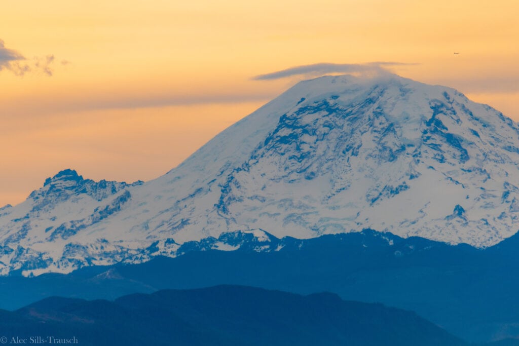
The best time to hike is on a clear day so that you can see Mount Rainier and the surrounding Washington mountains. On the day that we hiked, it was clear and gorgeous!
What pass do I need to hike Poo Poo Point?
You do not need a hiking pass to do Poo Poo Point. This is on city land, and no permits are required to recreate.

Hiking up to Poo Poo Point on the Chirico Trail
The trail up to Poo Poo Point is a pretty straightforward hike. Once parking, you pass the para-gliding/hang-gliding landing area, so keep your eyes open for people coming to land.
Make sure to give them right of way.
Once you pass the open field, you’ll walk down a short slope before beginning on the Chirico Trail.
Over the next two-plus miles, there is a consistent incline on your way up. It’s never too steep, but it also never really gives up. This means you’ll be in a constant state of breathing hard as you ascend to Poo Poo Point.
I’m pretty active, but we had to take a few breathers on the way up.
As you near the top (1.6 mile mark), you’ll encounter a split in the trail. The main trail goes to the left and is less steep. To the right is a shortcut that is not the actual trail. It’s steeper, and I wouldn’t recommend going on it, as we shouldn’t be creating new trails for fun.
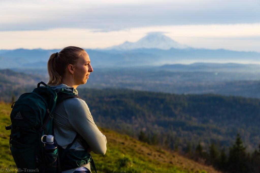
Then, at the 1.8-mile mark, you’ll reach the south launch area. This is where you’ll have views of Mount Rainier. It was stunning to see the giant volcano fully out. Additionally, we also saw a man gearing up to jump.

On this side, there are a few benches to sit on and a grassy area. We were not alone.
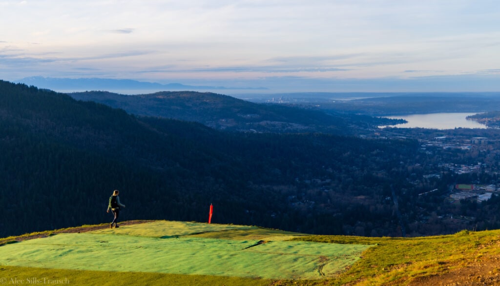
After the man jumped, we continued on the trail for another quarter mile toward the north launch area. This is the official Poo Poo Point area with a bathroom and some picnic tables.
From here, you’ll have views to the north and should be able to see Mt. Baker on a clear day. You’ll also have views of the Washington Cascades, the Olympic Range, and downtown Bellevue.
When you head down, you’ll go down the same trail you came up with. It’s a lot of pounding due to its steepness, but it’s not too challenging. Just ensure your shoes are not too tight/small, or your toes will hurt by the end.
Related: Winter Hiking Gear Guide
If you are planning to watch the sunset, make sure to wear a headlamp. The forest gets dark, and you’ll have almost no light.
What gear should I bring?
Poo Poo Point is a pretty standard hike, so you just need day hiking material.
Hiking shoes or trail runners
- Hiking Poles
- Mid-sized backpack
- Snacks
- Blanket if you want to sit and watch paragliders
- Water
- Hat
- Sunglasses
- Hiking shirt and shorts
- Wool hiking socks
- Camera/Phone
More Photos from Poo Poo Point


FAQ: Hiking Washington’s Chirico Trail to Poo Poo Point
Is there cell service at the top?
Yes, you will have cell service on the top of the hike. Once you’re out of the trees, you have a clear shot of cell towers around the Issaquah area. The best spots for service will be the paragliding launch points.
Are there bathroom facilities anywhere?
Yes, there is a bathroom near the north paragliding runway. It’s a little ironic. You can do your poo-poo at Poo Poo Point. (HAHA)
There are no facilities at the parking lot.

Can you fly a drone at Poo Poo Point?
Yes, you can fly a drone from Poo Poo Point. However, ensure your drone is clear of anyone paragliding or hang gliding at the top. Safety is the utmost concern here.
Can you paraglide on Poo Poo Point?
Yes! That’s one of the main attractions of the area. Paragliders and hang gliders jump off Poo Poo Point each day and soar down to the bottom. It’s a pretty great way to get down if you ask me!
We even saw a couple of people fly when we were up top.


Are dogs allowed on the trail?
Yes, dogs are allowed on the Poo Poo Point Trail. Make sure to pick up after them and bring enough water and snacks for them to enjoy the hike.
What is the elevation of Poo Poo Point?
The highest point on the trail sits just above 1,800 feet. This will provide you with some fantastic views of the surrounding area. However, you cannot see downtown Seattle from Poo Poo Point.
Can you drive up?
You cannot drive up to Poo Poo Point. While there is a dirt road, it is only for service vehicles, and no public use is allowed on the trail. Bikers are allowed to use the road, though.
Final thoughts on the Poo Poo Point Trail
This is a perfect trail for those looking to be active around Seattle and looking for a great view of the mountains. I’m not sure if this is something you need to do again and again (unless you live nearby), but every local should do it at least once.
Overall, it’ll get you sweating, but it’s not an overly challenging trail and one that is good for the entire family (over the age of 7 unless you’re carrying them).
I strongly recommend Poo Poo Point and feel you’ll have a great time on your hike!