
Incredible Views Await at Sarrail Ridge in Canada
If you’re looking for one of the best hikes in Kananaskis Country, hiking to Sarrail Ridge via Rawson Lake is about as good as it can get in Canada. It’s a mellow trail for half of it and then turns into a steep climb from the lake to the ridgeline.
But once you’re up there, the views are about as dynamic as they come and will blow your mind for the entirety of your visit. I can’t recommend this hike enough, and the photos should inspire you to add it to your bucket list, just like they did for me.
Easy Booking: Expedia.com | Hotels.com | VRBO | Booking.com
Need Gear: Find Gear at REI
Find Awesome Tours: Viator.com or GetYourGuide.com
Follow on Instagram: @Alecoutside
Iceland on your bucket list? Get my Iceland guide + 144 pinned locations on Google Map
How to hike to Sarrail Ridge and Rawson Lake
Quick Trail Details:
- Distance: 8 miles
- Elevation Gain: 3,500 feet
- Difficulty: Hard
- Estimated Time on Trail: 5-7 hours
- Pass: Kananaskis Country Pass
My Trail Report for Sarrail Ridge and Rawson Lake
It was a beautiful day when we woke up in the Elkwood Campground for our first full day in Peter Lougheed Provincial Park. After checking out the visitor center, it began to snow. And it kept snowing. We eventually drove to the parking lot to meet our friends and sat there for almost 30 minutes waiting out the storm.
Once it slowed down, our fivesome hit the Rawson Lake and Sarrail Ridge trail. We didn’t know it then, but we were headed on an incredible adventure with views that would blow us away.
The trail is divided into three parts: the easy walk along the lake, the uphill push to Rawson Lake, and the ascent to Sarrail Ridge.
To Rawson Lake

We cruised on the flat portion. Once the uphill started, my Seattle lungs began to feel the pain. The main uphill portion is a mile and just under 1,000 feet of gain to the lake. It’s comprised of switchbacks and walking on wooden beams (that I can attest are slippery when icy). I’d estimate this portion to take 30 minutes. Once we arrived at the lake, snow began coming down harder, and we were in a snow globe.
The views were gorgeous, and I couldn’t believe how surreal it all was!
Hiking up to Sarrail Ridge

After photos and a little break, our group began the clockwise trail around the lake. The trail “officially” ends around 8 o’clock, but you can see a defined path next to the lake. This path winds around the lake and begins to curl right.
This is the start of your incline to Sarrail Ridge.
It starts gently and then rapidly steepens, forcing us onto all fours at some points. There a 30 foot section that has ropes to help you up a rocky and slippery section. (Don’t worry, there’s no fall/injury risk. It’s just there to make your life easier.)
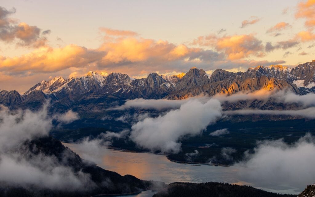
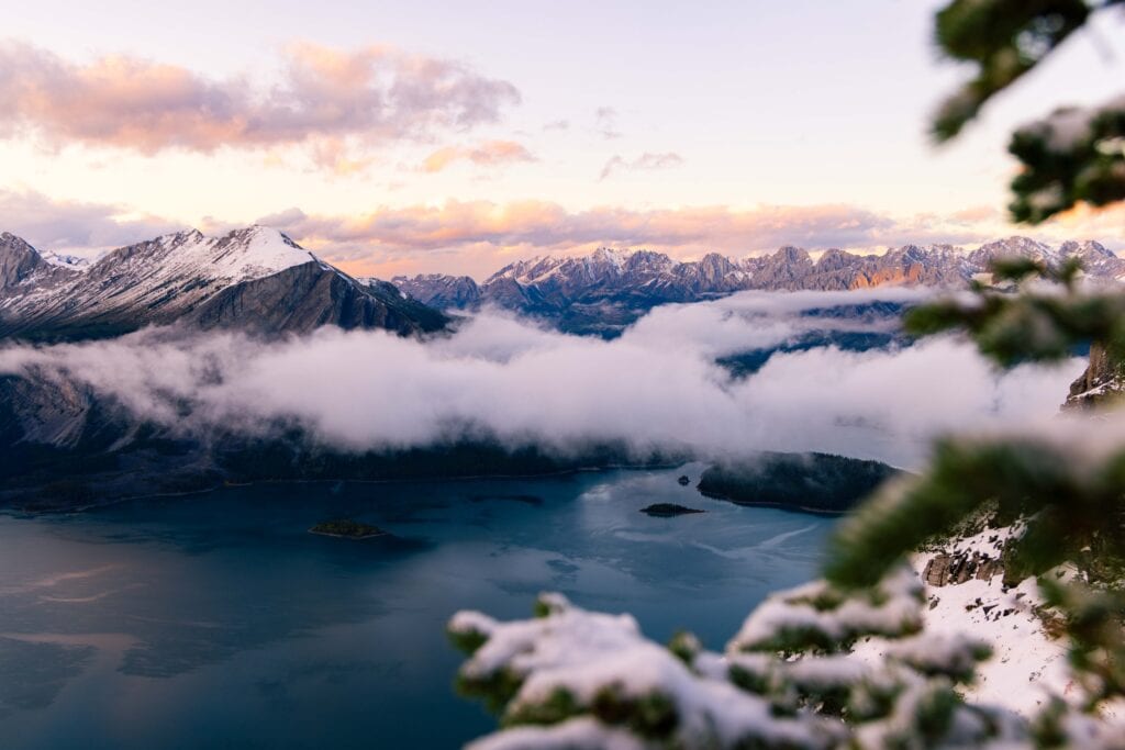
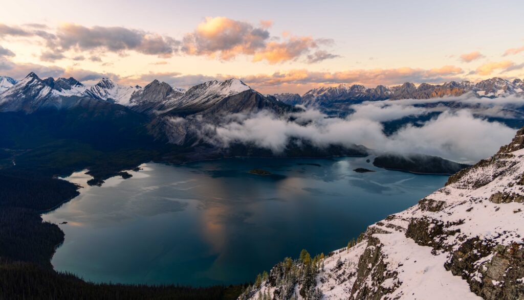
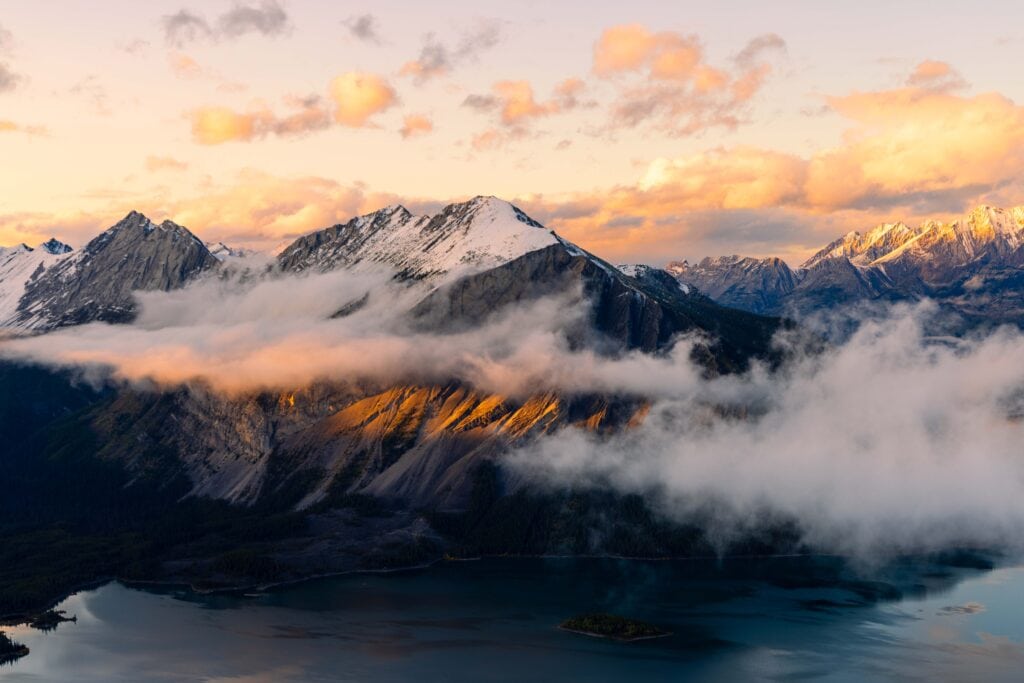
As we crested the top and finally looked out over the lakes, I was in awe. It was indeed one of the most incredible views I’d ever laid eyes on. Shimmering lakes. Jagged peaks in all directions. Snow capped.
If there was a perfect scene, it was this.
Photographing at the top and heading down
I meandered all over, exploring different compositions and angles, though, at some point, it all blurred together. While my friends decided to head down, I waited a little longer for early sunset colors on the clouds and peaks.
That said, I didn’t want to spend too long up top and have to hike the entire trail alone through grizzly country.
I safely descended the gully and quickly made my way around the lake. It was completely dark when I began heading down the switchbacks and into the forested section. So, headlamp, phone, and beautiful singing voice emerged, and I talked and sang the entire way down.
My Top Six Fall Hikes in Kananaskis Country
What you need to know about hiking Sarrail Ridge
Bear Spray
As with all trails in the Canadian Rockies, please bring bear spray and have it in a place where it is accessible throughout your hike. Kananaskis Country has a higher proportion of bears due to fewer visitors, so you have a higher chance of encountering one.
What part of Canada do I find this trail?
Sarrail Ridge and Rawson Lake are in Peter Lougheed Provincial Park in Kananaskis Country, south of Banff and Canmore. This area is one of the most striking in the Canadian Rockies, with towering peaks and deep valleys.
Where is the trailhead located?
The Rawson Lake and Sarrail Ridge trailhead is found at the Upper Kananaskis Lake Day Use area. It’s in the furthest parking lot that you can drive to. The parking lot is decently sized, though I could see it filling up on a summer weekend.


Should I stop at Rawson Lake or keep going up to Sarrail Ridge?
If you’re looking for a more casual hike (Rawson Lake is still a decent uphill at two miles and 1,000 feet of gain), then hang out at the lake. But if you’ve got the time and are in good enough shape, hiking up Sarrail Ridge is incredible, and the views will absolutely blow you away.
The gully is no joke.
It is incredibly steep and either slippery or muddy. It had just snowed during our hike, so it was quite slick. We were huffing and puffing throughout the entire incline.
You’ll see your route up once you reach the back of the lake. Straight up. It’s about a half mile and 1,000 or so feet to reach the ridge.
I’m sure it took us 45 minutes or longer to reach the top. But it didn’t seem terrible. We kept each other’s spirits high and took plenty of breaks.
When is the best time of year to hike?
Summer and fall are hands down the best and safest times to hike Sarrail Ridge. As for Rawson Lake, this is far more accessible year-round (though winter will obviously be snowy), and there is far less avalanche risk as you’re in the trees.
I would assume the gully to the top of Sarrail Ridge is prime avalanche territory and to use immense caution.

Are there fall colors at Sarrail Ridge?
You won’t have much fall colors while on the trail to Rawson Lake or at the lake. But once you reach the top of the ridge, you’ll notice larches below you as you look out at the gorgeous views of Upper and Lower Kananaskis Lakes.
What Gear Do I Need
- Wide-brimmed hat
- Sunglasses
- Sun shirt or sun hoodie
- Hiking Shoes or Trail Runners
- Hiking Shorts or Hiking Pants
- 25L+ Hiking Pack
- 2L hiking bladder or water bottles
- Garmin inReach 2
- Garmin Fenix hiking watch
- Light jacket for mornings
- Hiking Poles

Staying Overnight in the Area
There are numerous camping options in the Kananaskis Country area, but few hotels. I stayed at Elkwood Campground for my fall trip in 2024. In the summer, though, there are a half dozen or more in the larger Kananaskis Country region.
Here are the ones near the Sarrail Ridge trailhead:
- Elkwood Campground
- Boulton Creek
- Lower Lake Campground
- Mount Sarrail Campground
- Kananaskis Interlakes Campground
Final Thoughts on hiking Sarrail Ridge and Rawson Lake
The Sarrail Ridge hike is absolutely incredible and one of my favorites I’ve every done. It actually came in No.2 for my top 2024 hikes. I have no doubt that if you’re physically fit, you’ll also enjoy the heck out of this trail and leave with 10/10 memories as well.
Until next time, adventurers, stay safe.
Follow on social media: TikTok || Instagram || Facebook || Newsletter | YouTube