
Ultimate Guide: Hiking and Backpacking Wing Lake in the North Cascades
Wing Lake in the North Cascades is one of the most brilliant places to hike and pitch a tent in the entire area. The landscapes are dramatic, the views humbling, and while the rest of the world hikes around the Maple Pass Loop, comparatively few make their way to this alpine heaven.
If you’re just day hiking it, it’s not tremendously difficult, but it is a long day, with a boulder field to cross and a final mile push that gains you over 1,200 feet. That, in my view, was the worst part.
However, it is incredible once you’re in the Wing Lake basin.
Overall, it’s a truly memorable hike, and we’ll dive into everything you need to know for hiking and backpacking Wing Lake! Thanks for reading and enjoying the photos!

Your Guide to Hiking and Backpacking Wing Lake
Lace up the boots and toss on the pack. Let’s get going.
What you Need to Know Before your Wing Lake Hike
Do you need a permit to backpack Wing Lake in the North Cascades?
No permit is needed to backpack here. Many people think this is inside the North Cascades National Park, but it’s not. It’s just good ol’ National Forest land. Due to this, it can get crowded on weekends. Please be respectful of those around you and do your best to follow the Leave No Trace Principles. When camping, use durable surfaces and, if possible, maintain a distance of 100-200 feet from the lake.
Wing Lake Trail Difficulty
I would say this is a challenging but not unbearable trail. 60% of the trail is relatively moderate, from the trailhead to the boulder field. From there, it’s standard route finding and being cautious about stepping on secured boulders and not falling on your face.
Then, the last mile, or 20% of the trail, is arduous. That part took me 75 minutes. There were points where I’d rest, walk 10 yards, and then rest again.
However, I did it eight months after a stem cell transplant and my second cancer treatment. It was my most demanding hike since treatment, and it took me three hours and fifty-five minutes, including stops and photos.
I shaved 30 minutes off the return trip, although I stopped for a while to enjoy the views of Lake Ann, and I’m not sure if my watch also stopped.

Wing Lake Trail Length
The Wing Lake hike is around 5.5 miles to get there, according to my Garmin. Round trip, it’s about 10 miles.
What is the elevation gain to get to Wing Lake?
My watch clocked me in at just over 2,700 feet with an additional 680 feet of decline. So, overall, there was about 3,400 feet of elevation change getting there.

How to get to Wing Lake?
The Wing Lake hike begins at the Maple Pass Trailhead. From there, hike up and turn right towards Heather Pass and Lewis Lake. Continue on the trail as you cross the boulder field, past Lewis Lake, and then up to Wing Lake.
What did I bring for my backpacking trip?
- 3 Person Tent
- 65L backpack
- 15-degree sleeping bag
- Sleeping Pad and Ridge Rest
- Freeze-dried meal, snacks, electrolytes, and coffee
- Canon R5, 24-105 f/4, 70-200 f/2.8, DJI Mini 3 Pro (See my entire camera set up.)
- 3L gravity water filter
- Jet Boil
- REI Backpacking Chair
- Down jacket, Sun Hoodie, Fleece, Wool Sleeping Pants, Wool Socks, Wool Shirt, Beanie, Gloves, Headlamp, Hiking Boots
Is There Water on the Trail?
Yes, there is water on the trail, though not until the 3.75-mile mark. Your first water opportunity will be when you cross the stream just below Lewis Lake. You can filter water here or wait until you reach Lewis Lake.
Then, there’s water at Wing Lake, which shouldn’t be much of a surprise, haha.

What is the elevation of Wing Lake?
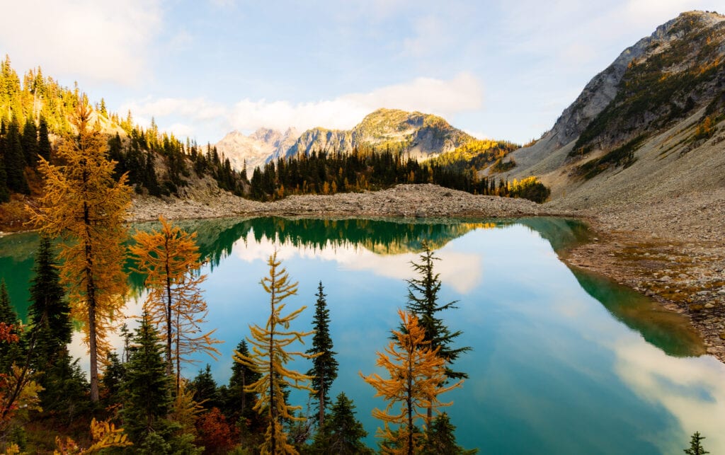
Wing Lake sits just below 7,000 feet in the North Cascades and 2,000 feet below the summit of Black Peak. While not tremendously high versus the likes of Colorado, you will feel it in your lungs, as it’s one of the highest lakes in the area.
Additionally, it can get quite chilly in fall – close to freezing or below – so keep that in mind when you visit.
Is this a sunrise or sunset spot?
Wing Lake is a sunrise spot, especially in the fall when the larches are backlit and have the most amazing glow. It’s a truly, truly incredible view and one you should wake up for!
The Best Time to Visit Wing Lake
Summer at Wing Lake
If you’re looking for the best weather, summer is a perfect time to hit the trails to Wing Lake. Your weather should be incredible, and you’ll have long days to enjoy the trail and views.
Plus, this trail gets crazy crowded for fall colors because of the larches, so you might have it a bit more to yourself. Furthermore, this is the best time to try to summit Black Peak, which rises directly behind Wing.
It’s a class 2/3 scramble but not too technical if you’re into that sort of thing.
Incredible Hiking at Joffre Lakes
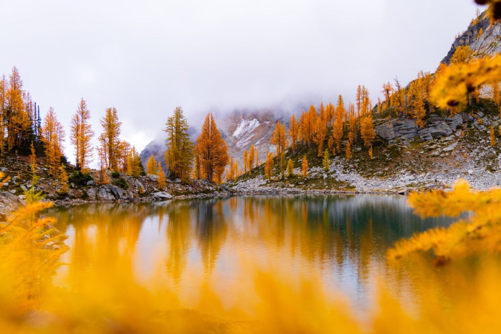
Wing Lake with Fall Colors
Now, this is where the Wing Lake hike gets its fame! There are a TON of larches at the lake and in the right light, absolutely magical! I’ve seen my fair share of larches, and I think this one takes the cake for the best backdrop in Washington.
On the Trail to Wing Lake
All right! Let’s dive into the hike. I’ve broken this down into five parts.
Starting at Maple Pass Trailhead
This is the easiest part, albeit the most crowded.
Take the trail toward Maple Pass, and you’ll gently ascend, eventually seeing Lake Ann on your left below after a mile. It’s a stunning view. Then, you’ll have a few switchbacks that bring you higher up the slope, but they won’t be too challenging.
Around the 2.2-mile mark, you’ll see a side trail going right and a sign about protecting the meadow. This is your turn-off towards Heather Pass.

Head right towards Heather Pass and Lewis Lake
It’s a flat/downhill trek to the boulder field. But first, if doing this in the fall, enjoy a sea of larches. It’s magical!
As you descend, do your best to stay right and as close to the trees as possible. This will provide you with a small boot path versus going over the boulder field. It’s not the straightest shot, but it’s the easiest, in my opinion. For the entirety of the boulder field, if you can stay near the trees, do so.

Crossing the Boulder Field
Now, you do have to cross the boulders at some point. There are cairns to help guide you and obviously people too if present. I found the way back easier to navigate versus going there, which I think is simply due to being more familiar with the terrain.
This part was slow going, with a heavy backpack and attempting to find the safest and easiest route across.
I think the boulder field took me about 25 minutes, though it felt much longer!

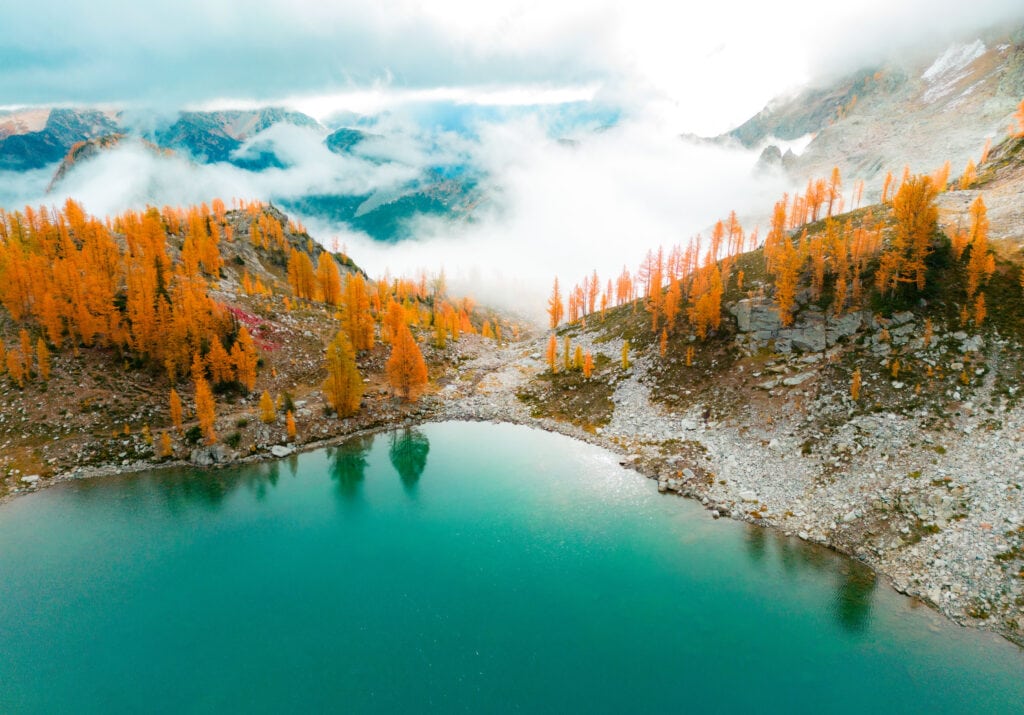
Reaching Lewis Lake
Find your trail again, and you’ll quickly cross over the stream running out of Lewis Lake. The main trail takes you counter-clockwise around the lake, but there is a shorter and more direct route on the left side if you so choose.

Either way, you want to reach the backside of the lake before heading up to Wing Lake. Here, the trail is back to being in good condition, and you’ll have no problem following it up.
The Uphill Push to Wing Lake
One thousand two hundred feet up through larch heaven. You’ll have to do that over the next mile to reach the basin. If you’re backpacking Wing Lake, this will be tough, thanks to tired legs, but you’ll make it there eventually.
This portion took me 75 minutes or so, and I was pretty exhausted at the end. However, the views are pristine, and I was enamored with the larches on the way up (and down).


Once at the top, I met up with my buddy, who left before me and settled into camp. We had a foggy night and morning, so there was no golden glow as we’d hoped. Still, it was a great time, and I couldn’t have been happier with how everything went!
More Photos from the Wing Lake Hike
Enjoy these photos of Wing Lake.


FAQ: Hiking and Backpacking Wing Lake
How hard was the final uphill from Lewis Lake to Wing Lake?
It’s a brutal uphill climb with 35-40 pounds on your back (including photography gear). The trail, though, is straightforward and in great shape.
It’s just damn hard, and coming from Seattle, hiking up around 7,000 feet is quite the altitude change!

How many camping spots are at Lewis Lake? And at Wing Lake?
There are only a couple of spots to camp at Lewis Lake, and they are on the north side of the lake (the only side that isn’t a boulder field). I saw a couple of really big campsites, but not much in terms of privacy.
As for hiking Wing Lake, you have a lot more options. The best spot is about halfway up the right side of the lake. However, you can expand out and find plenty of others – with or without privacy.

What were the crowds like during the weekdays?
Crowds are vastly different on the weekdays vs the weekends. Only two others were at Wing Lake when we camped on a Wednesday. However, on weekends, it can have 15 different groups packing into the basin.
If you can go backpacking Wing Lake during the middle of the week, do it. You’ll have a much more pleasant experience.
What other areas are great fall hikes in Washington?
I recommend checking out my best fall hikes in Washington guide. It’s packed full of great spots and some that get few crowds.

Wrapping up – Adventuring to Wing Lake in Washington
There you have it! Backpacking Wing Lake was an incredible experience and one I can’t wait to do again with a little better conditions!
I hope your Wing Lake hike is as memorable as mine and helps connect you better with nature and the surrounding North Cascades.
Until next time, adventurers, stay safe.
Follow on social media: TikTok || Instagram || Facebook || Newsletter | YouTube