
The 11 Best Hikes on Highway 2 in Western Washington
It can feel a bit overwhelming trying to figure out where to go on a hike during the summer in Washington. You have so many options that you get a little shellshock. However, I’m here to highlight why these best Highway 2 hikes should be on your radar and why they are among the most accessible in the entire state.
The top hikes on Highway 2 are around 70-100 minutes from Seattle, giving you a much shorter drive to find awesome views as opposed to driving up to Mount Baker or the North Cascades Highway.
If you’re ready to hit the trails, keep reading, and hopefully you’ll find a hike that suits your fancy!
Easy Booking: Expedia.com | Hotels.com | VRBO | Booking.com
Need Gear: Find Gear at REI
Find Awesome Tours: Viator.com or GetYourGuide.com
Follow on Instagram: @Alecoutside
Iceland on your bucket list? Get my Iceland guide + 144 pinned locations on Google Map
My Favorite Hikes Along Highway 2 Near Gold Bar, Stevens Pass, Leavenworth, and More!
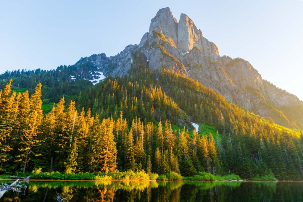
1. Lake Serene
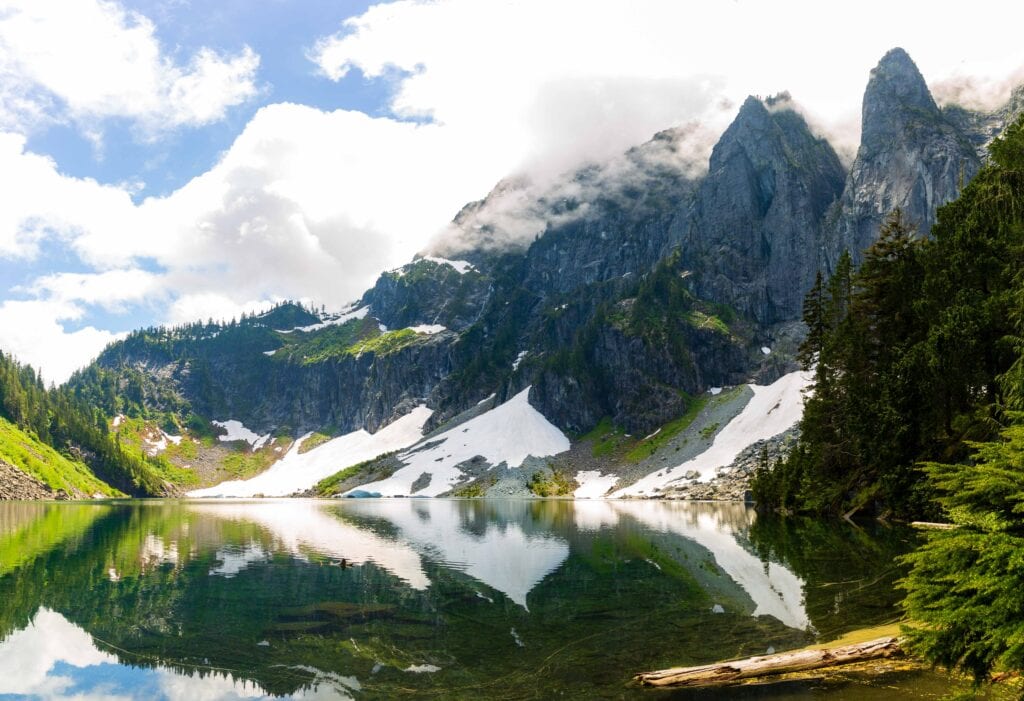
Starting off with one of the best hikes in Washington (and one that most people have heard of). Lake Serene is less than 75 minutes from Seattle and packs a serious punch. It even comes with a waterfall that only requires a short detour.
Lake Serene was my first hike after moving to Washington, and the 2,000 feet of gain was felt! But dang, the views at the lake were incredible, and I enjoyed every second of the trail.
If you plan to hike on a weekend, expect a lot of people. My suggestion is to either arrive around 7:00 a.m. or to show up around 3:30 p.m.
Distance: 8.2 miles
Elevation Gain: 2,000 feet
Difficulty: Moderate-Hard
Location: Lake Serene Trailhead
Find all of these hiking trailheads on Overlook Maps
2. Heybrook Lookout
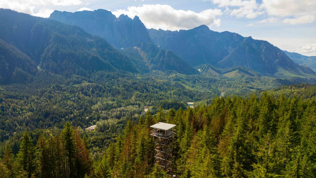
Just past the Lake Serene Trailhead is Heybrook Lookout. It’ll sneak up on you as the parking is on the side of the road, just beyond the National Forest sign.
This is a short trail to the lookout, but you’ll burn calories as it’s up, up, up. Thankfully, the forest here is healthy, green, and mesmerizing. You’ll definitely enjoy soaking up all the views as you hike away from Highway 2.
Once at the lookout, you’ll have a couple of stories to climb to reach the top. Here, enjoy the majestic views of the Washington Cascades, and you’ll see why it’s one of the best Highway 2 hikes in Washington.
Distance: 2 miles
Elevation Gain: 980 feet
Difficulty: Moderate
Location: Trailhead along Highway 2 (use your turn signal early and be aware of oncoming traffic)
3. Index Town Wall
This is a quick hike to one of the more unique views in Washington. I haven’t done it, but it looks like a fun hike, but probably not for those scared of heights, as the end has you staring down 1,000 feet to the valley below. Be aware that the trail is quite steep and not maintained, so use caution when trekking.
This is also a good opportunity to explore the small town of Index. Grab a bite or drink and enjoy the mountain views!
Distance: 2.5 miles
Elevation Gain: 1240 feet
Difficulty: Hard
Location: Trailhead
5-day Itinerary: Leavenworth and Lake Chelan
4. Blanca Lake
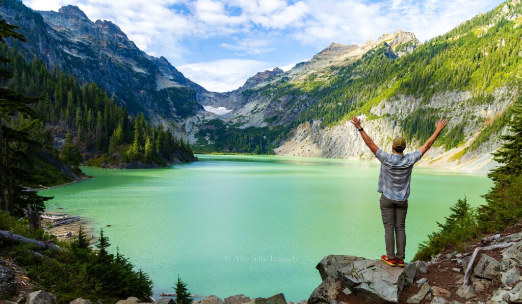
Blanca is an ever-popular hike to one of the most glacier-blue lakes you’ll see in Washington. The trail starts immediately uphill and doesn’t relent for a while! The good (or bad) part of the hike is that once you gain a bunch of elevation, you have to drop down quite a bit to reach the lake on the other side of the mountain. So, the elevation gain you see below is a bit deceiving, as you’ll have an uphill there and back.
But the lake is beautiful, and it’s a great place to spend a summer day. The road is paved for almost its entire length (you’ll pass Index), but the last mile or two is a bit bumpy; however, all cars should be able to make it.
Distance: 8 miles
Elevation Gain: 3,400 feet
Difficulty: Hard
Location: Blanca Lake Trailhead
5. Deception Falls
Below Stevens Pass on the west side is Deception Pass. It’s a beautiful area to take the family and hike amongst the mossy trees along the creek. There’s a nice loop trail to take that isn’t hard at all. You’ll want to stop here when driving west, as there’s no designated turn lane into the small parking lot.
This doesn’t open until later in the spring, but once it does, you’ll see why it’s one of my top Highway 2 hikes and places to explore.
Distance: 1 mile
Elevation Gain: 100 feet
Difficulty: Easy
Location: Parking Lot
Don’t Miss: Best Fall hikes in Washington
6. Lake Valhalla
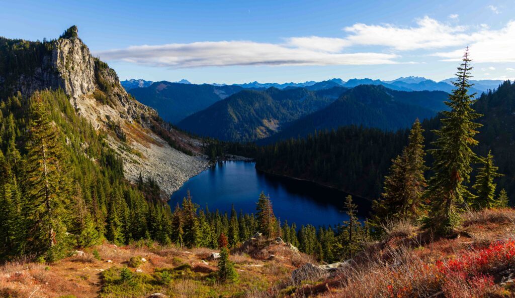
This is a blast of a hike. Lake Valhalla is super popular and for good reason. The trail is pretty moderate (switchbacks to begin, then it chills out), and it hikes along the PCT for part of it. Once at the lake, you’ve got beaches to enjoy, or you could hike up Mount McCausland for a summit party.
It’s also an excellent hike for fall colors, as the reds blanket the mountainside.
Distance: 6-7 miles
Elevation Gain: 1,500 feet
Difficulty: Moderate
Location: There are two trailheads. One is the PCT via Stevens Pass, the other is not. The shorter route is non-PCT and the one I recommend.
6. Skyline Lake Trail

This is a butt burner! It’s a steep, yet short hike to a lake that sits opposite Stevens Pass Resort. I did it with my parents in May of 2023, and it was still totally frozen, and the trail was snow-covered for the second half. If you’re in need of a quick hike, this will suffice, but there are definitely better options out there.
Distance: 2.5 miles
Elevation Gain: 1,050 feet
Difficulty: Moderate/Hard
Location: Stevens Pass Lot D
7. Wallace Falls State Park

If you’re looking for a great family-friendly hike that isn’t too hard but has some great payoffs, Wallace Falls is the place to be. You’ll hike along a creek before hitting three fantastic waterfalls. It might be my favorite hike along Highway 2.
The incline is mostly at the end, to reach the second and third waterfalls. Trust me, it’s worth it!
Distance: 6 miles
Elevation Gain: 1300
Difficulty: Moderate
Location: Wallace Falls State Park
8. Thunder Mountain
Thunder Mountain is another trail that escaped me when I lived in Seattle and offers gorgeous views within the Alpine Lakes Wilderness. You can do it as a day hike, but it’s best done as a backpacking trip. It’s a tough cookie, but you’ll be hooked on the views once you get high enough.
Distance: 12.5 miles
Elevation Gain: 4000 feet
Difficulty: Hard
Location: Tunnel Creek Trailhead
The Best Larch Hikes in Washington
9. The Enchantments and Colchuck Lake
Okay, we’re taking a slight stretch here because this isn’t that close to Highway 2. That said, you still have to take it to get there, so we’ll be generous on this one. If you want some guides, here are my articles from this hike.
- Thru-hiking the Enchantments
- A better way to hike the Enchantments
- Guide to Backpacking the Enchantments: Day 1, Day 2, Day 3, Day 4
Distance: Enchantments Thru Hike: 18-20 miles (Colchuck Lake: 9 miles RT, Stuart Lake: 9 miles, a bit easier than Colchuck)
Elevation Gain:
Difficulty: Strenuous
Location: 25 minutes outside of Leavenworth
10. Icicle Ridge
This one is just outside of Leavenworth and is a great place to go hiking along Highway 2! I never got around to hiking the trail here, but it is a perfect late spring/early summer hike with gorgeous lupines and yellow flowers dotting the trail. It still had decent elevation gain, but it’s also a “choose your adventure” hike, as once you reach the ridge, you can continue hiking for a while.
Distance: 6 miles
Elevation Gain: 1800 feet
Difficulty: Moderate to Hard
Location: Icicle Ridge Trailhead
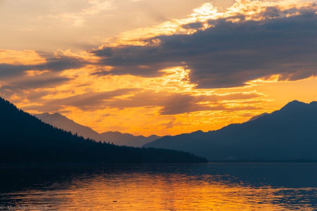
11. Barclay Lake
One of the biggest bang-for-your-buck hikes on this list. Hiking to Barclay Lake doesn’t require much effort, and the payoff is immense, especially at sunset when the light hits the towering Baring Mountain and lights it up like a beacon.
You’ll want to do this in June or early July before the lake dries up considerably and the iconic reflection disappears.
One thing to note is that the road here is not great. You’ll want some clearance to be safe. (My friend’s Subaru Crosstrek did just fine.)
Distance: 4.5 miles
Elevation Gain: 500
Difficulty: Easy to Moderate
Location: Barclay Lake Trailhead
Places to stay along Highway 2
The main draws for Highway 2 are Leavenworth, Cashmere, and Wenatchee. There are a few places to stay on the western side, but it’s not as built up.
Inside Leavenworth:
- Enzian Inn (Mid-tier)
- Linderhof Inn (Mid-Tier)
- Hotel Leavenworth (Budget-Friendly)
- Alpen Dorf Pension (more expensive)
- Obertal Inn (Mid-Tier)
- Bavarian Lodge (more expensive)
- LOGE Downtown Leavenworth (Budget-friendly)
- Leavenworth Village In (Budget-Friendly)
- Hampton Inn and Suites (budget-friendly)
Less expensive options further east:
- Cashmere Inn
- Springhill Suites by Marriott
- Residence Inn by Marriott
- Best Western
- Holiday Inn Express
Summer Hiking Gear for Highway 2 hikes

- Wide-brimmed hat
- Sunglasses
- Sun shirt or sun hoodie
- Hiking Shoes or Trail Runners
- Hiking Shorts or Hiking Pants
- 25L+ Hiking Pack
- 2L hiking bladder or water bottles
- Garmin inReach 2
- Garmin Fenix hiking watch
- Light jacket for mornings
- Hiking Poles
Exploring Washington’s Highway 2 to Stevens Pass and beyond
What is Highway 2?
Highway 2, also known as Stevens Pass Highway, is one of the most popular routes in Western Washington for heading into the mountains for superb hiking and breathtaking views in the Alpine Lakes Wilderness and Mount Baker Snoqualmie National Forest. It’s one highway up from the Mountain Loop Highway, with the town of Monroe starting your journey into the Cascades.
This route is popular due to A) its connection to Stevens Pass, one of the major ski resorts in Washington, and B) being the quickest route to Leavenworth, a highly popular tourist destination known for its beers, wines, and good times.
How far is it from Seattle?
The best Highway 2 hikes start at Wallace Falls State Park, about an hour from Seattle. Over the next 60-100 minutes, you’ll find incredible hiking opportunities on both sides of the valley.
If you’re in central or north Seattle, you’ll hop on Interstate 5 and drive north, exit onto the 405-South, and finally exit toward Highway 2 going east.
Avoid Highway 2 on Sunday Evenings
The biggest takeaway I hope you can take from this is that the worst place to be on a Sunday afternoon or evening is driving west on Highway 2 back to Seattle. It’s not a traditional highway.
It passes through a handful of small towns and a couple of stoplights, completely backing up traffic for miles and miles. There’s really no way to avoid this if you are only going to Stevens Pass or Lake Wenatchee. If you’re visiting Leavenworth or Wenatchee, consider taking Blewett Pass (Highway 93 to Interstate 90), which can be a faster route.
Usually open year-round
With the ski resort at the high point of Highway 2, this road is almost always open and is plowed daily/hourly. That said, it will be snowy, and once you get over Stevens Pass in the winter, the temperatures drop dramatically.
I was at Lake Wenatchee one winter, and the temperature was 19°F; yet once you reached the pass, it warmed up considerably.
Wrapping up the best hikes on Highway 2
These Highway 2 hikes in Washington are some of the best in the state and give you easy access to the outdoors without driving too far from home. From easy to challenging, you have lots to choose from as you set out on an adventure in the Washington Cascades.
Happy hiking ya’ll and thanks for reading my best hikes on Highway 2.
Until next time, adventurers, stay safe.
Follow on social media: TikTok || Instagram || Facebook || Newsletter | YouTube