Hiking and backpacking to epic Big Pine Lakes in California
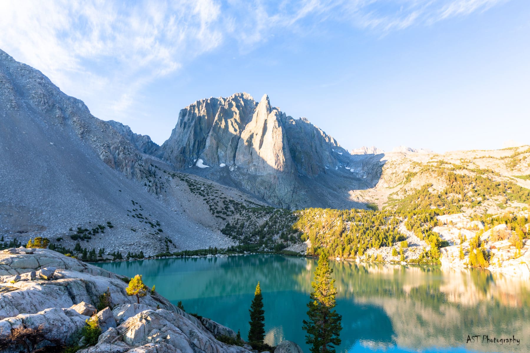
Temple Crag emerged from behind a bend as I hit the five-mile mark on my trek backpacking Big Pine Lakes Trail. Below it, Second Lake, looking like the headwaters of the blue Gatorade flavor, peered back at me. I had made it, and I was ecstatic (and tired).
Backpacking Big Pine Lakes had been on my bucket list for a few years since I saw photos of the stunning Eastern Sierra scenery. With permits nearly impossible to land, I was lucky to find one on short notice. While it’s not a tremendously challenging hike, the lakes sit above 10,000 feet, and altitude plays a factor.
Coming from sea level and hiking that day, I felt the lower oxygen levels. If you follow a similar path, take it slow and don’t skimp on breaks.
Why you can trust me: You can trust that this review is authentic and real because I actually backpacked here, and I highly recommend it. I try to use my blog as I talk to my friends, and the Big Pine Lakes area is one you’ll be stoked about!
Ultimate Guide to Backpacking and Hiking Big Pine Lakes

Hiking Stats for Big Pine Lakes
- Distance: 11-20 miles, depending on where you go
- Difficulty: Hard
- Elevation Gain: 2,500 to 4,500, depending on your destination
Trail Report: Hiking to Big Pine Lakes!
Everything you’ll need to successfully hike or backpack Big Pine Lakes Trail.
The Trek on the Big Pine Lakes Trail
For overnight hikers, park in the designated Overnight Lot. You can’t miss it driving in. From here, you’ll begin the journey to the North Fork of Big Pine Creek. The first two miles can be warm and taxing, with no shade until you get into the trees above the waterfall.
After that, however, it’s not a steep approach until a series of switchbacks at the two-mile mark. Once above the waterfall, you’ll have more shade, and the nearby river will help keep the temperature down.
The final three miles to First Lake and Second Lake have switchbacks and gradual inclines. It’s nothing complicated at all. It took me about 2.5 hours to get up with plenty of water breaks. Just before you hit the lakes, at the 4.5-mile mark, there’s a junction that can take you to Black Lake.
Take the cut-off if you’d like to do the totality of lakes in a counterclockwise measure. For example, black Lake has an elevation of 10,600 and is called ‘Black’ because it doesn’t have the blue-green glacier runoff color like the others (or this is my presumption).
Easy Booking: Expedia.com | Hotels.com | VRBO | Booking.com
Need Gear: Find Gear at REI
Find Awesome Tours: Viator.com or GetYourGuide.com
Follow on Instagram: @Alecoutside
Iceland on your bucket list? Get my Iceland guide + 144 pinned locations on Google Map
Choosing a Campsite: Hiking the Big Pine Lakes Trail
I slept above Second Lake for the first night with a view worthy of a gold medal. It’s the iconic view you see in most Big Pine Lakes photos. While the location has many perks, there are some negatives. First, you’re a hundred feet above the water and must walk a bit to fill up.
Second, I found out that evening that there’s no protection from the elements. So, after getting rained on and being in a lightning storm with no protection, I moved down to First Lake and used the trees as protection for night two.


From what I can gather, there aren’t many great campsites at Second Lake. On the other hand, First Lake has many camping options, with drinking water easily accessible. The Third Lake didn’t have many opportunities, either, due to the steep angle of the shores.
I also can’t speak to Lakes 4-7 as I have never ventured there. However, I did hear a big group camping up there, so I imagine ample spots along the Big Pine Lakes trail.
Gear I Used Backpacking Big Pine Lakes in California
- Light backpacking tent
- 15-30 degree sleeping bag
- Light, yet comfy sleeping pad
- 55L-65L backpacking bag
- Jet Boil Stove
- Water filter
- Hiking Poles
- Backpacking Chair
- Wide-Brimmed Hat
- Headlamp
- Backpacking Meals
- 1x Hiking Pants, 2x Sunshirt, 1x Down Jacket, 1x Rain Jacket, 1x sleeping shirt, 1x leggings, 1x beanie and hat
- Sunblock
- Backpacking Boots
Hiking to Palisade Glacier
As much as I wanted to see Big Pine Lakes, I really wanted to see Palisade Glacier. With the speed at which glaciers are melting these days, seeing them ‘alive’ is a notable feat. Palisade Glacier is unique because it’s the southernmost Glacier in North America.
From Second Lake, it’s about 1.5 miles to the Palisade Glacier trail branch. From here, you’ll begin your three-mile journey.


The first two miles are standard High Sierra trail. Then, after a series of switchbacks, you’ll find yourself in a glacier-fed meadow about halfway in. I found this beautiful.
Please take a moment to enjoy it before crossing the stream. For the final mile, you’ll begin boulder hopping. This last stretch is the hardest part of the hike. While there’s no “trail,” Cairns will help guide you like a lighthouse aiding a distressed ship to shore.
Once at the top, the view will wow you. You’ll be looking at snow that fell millions of years ago and is now being exposed to the modern world. Plus, even though you’re at 12,400 feet, towering peaks are still above you.
It’s a humbling experience.

Everything you need to know about hiking Big Pine Lakes Trail
Some need to know information about your hike or backpacking trip to Big Pine Lakes, California.
Can you hike to Big Pine Lake in one day?
Most definitely! It’s open to all hikers. I estimate it takes about two and a half hours to reach Second Lake if you hike at a consistent pace. Most people will be day-hiking to Big Pine Lakes rather than backpacking.
Where should I stay before/after my hike?
There are a handful of places to stay before you go backpacking or hiking Big Pine Lakes. First, if you want a hotel, stay in Big Pine. You can also look to Bishop (a short drive) for more options.
There are also camping sites very close to the trailhead.
- Sage Flat Campground
- Upper Sage Flat Campground
- Big Pine Creek Campground
Where is Big Pine Lakes located?
The Big Pine Lakes Trail is about a 30-minute drive into the mountains from the city of Big Pine. Big Pine is a town of 1,400 people, so keep your expectations in check when visiting.
It’s about 15 minutes south of Bishop (they have a great brewery to stop at after your hike), 55 minutes south of Mammoth Lakes, four hours from Los Angeles, and a nine-hour drive from Phoenix.
When is the best time to visit the Eastern Sierras?
You can visit the Eastern Sierra year-round, but hiking is predominantly from May through November (or when the snow starts). However, higher altitude hikes like this do not usually melt out until June.
Before visiting, I would check out trail reviews to see what gear you need to make your trek safely.

How long is the hike to Big Pine Lakes?
There are multiple routes to take for the Big Pine Lakes trail. However, the most straightforward approach to Second Lake and the Temple Crag view is 10 miles round trip.
If you’re looking to hike to the Palisade Glacier overlook, it’s 18 miles. However, if you complete all seven lakes and the Glacier, you’re looking at an estimated 22 miles.
What is the Starting Elevation?
The starting elevation of the hike is 7,600. The first 1.5 miles of backpacking Big Pine Lakes is brutal as it is in the sun with no shade.
What will the temperature be like at Second Lake?
You can expect the temperature to be about 6-10 degrees cooler than the temperatures in Big Pine, CA. Usually, during the summer, the temps are in the 60s or 70s, though I caught it on a warm weekend, and it was in the 80s.
What is the Elevation gain into Big Pine Lakes Basin?
The elevation gain for backpacking Big Pine Lakes is 2,500 feet to Second Lake. After that, it’s a challenging 4,800 feet gain to the Palisade Glacier. (Which I recommend you get to.)
How hard is it to hike Big Pine Lakes Trail?
I would consider this trail to be moderately hard for the lakes. However, if you plan to hike to the Palisade Glacier, it would be a strenuous hike due to elevation gain and distance.
Do you need a permit to hike Big Pine Lakes?
Permits are required for overnight camping only and are one of the most challenging permits to get in the area due to their popularity. If you plan to day hike, you do not need any permits.
However, if you’re backpacking Big Pine Lakes, you want the “North Fork – Big Pine Lakes” permits.
Anything to see after the hike?
How does a soak in some hot springs sound? While these aren’t natural, and there’s a small fee, the Keough Hot Springs are incredible and feel so good on achy muscles.
I went here after doing Whitney in a day, and it was life-saving!


Final Trip thoughts for hiking the Big Pine Lakes Trail in California
- Remember to Leave No Trace and Pack Out what you Pack In.
- Always be prepared for inclement weather. Start your hikes early and try to have them done by early afternoon.
- I’m not joking about the first two miles on the Big Pine Lakes Trail. They’re sweltering if you do it midday.
- Horses do frequent the trail. Get off the path and follow the leader’s directions when you see them.
- You can fill up water at the 2.2-mile mark (above the waterfall right after passing the Wilderness sign).
- Drones are not allowed.
- You are going to love backpacking the Big Pine Lakes trail. It’s surreal, beautiful, and peaceful.
Until next time, adventurers, stay safe.
Follow on social media: TikTok || Instagram || Facebook || Newsletter | YouTube