
Trail Report: A fantastic hike and view at High Rock Lookout
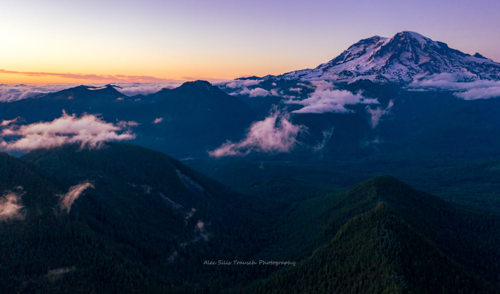
Only a few spots near Mt. Rainier National Park will blow your mind. Hiking the High Rock Lookout Trail is one of them. With unparalleled views of every inch of Rainier, the High Rock Fire Lookout will disappoint no one.
Sitting on the end of a cliff with 1,000+ foot drops in multiple areas, it’s not for the faint of heart or those scared of heights. But if those don’t bother you, you’ll be in heaven.
Easy Booking: Expedia.com | Hotels.com | VRBO | Booking.com | Airbnb.com
Need Gear: Find Gear at REI
Find Awesome Tours: Viator.com or GetYourGuide.com
First time here? Stay in touch by following on IG: @Alecoutside and my newsletter
Purchase my 2027 Scenic Calendar
Please stay safe out there and follow Leave No Trace principles as best you can.
Hiking Guide to High Rock Lookout Trail Near Mount Rainier
What you need to know about the hike
High Rock Lookout Trail Details:
- Length: 3.2 miles RT
- Elevation Gain: 1365 feet
- Difficulty: Hard – But the pain will be over quickly
- Total Time: 2-3 hours
- Route: Road 84 is good for low-clearance AWD
What sort of gear do I need to hike here?
- 32L – 40L backpack
- Hiking Boots
- Hiking Base Layer: Sun shirt (men’s) (women’s)
- Lighter Down Jacket
- Water filter
- Sunglasses, Wide Brimmed Hat, Sunblock
- Wind Jacket (Rain Jacket too if you think it could rain)
- Hiking Poles
- Headlamp
- Snacks
- Download the map offline

How big is the parking lot?
The parking lot is not that big. I would say it can hold 10-12 cars. I would recommend visiting this on a weekday when visitor numbers are lower.
How hard is High Rock Lookout?
It’s a tough butt burner, but it’s a short hike. Once you start to get tired, you’ll be all done and ready to enjoy the sights!

What kind of car can make it to High Rock Lookout?
I would say most cars can make it if the road is dry. The last time I went, in 2020, we made it to High Rock Lookout in a standard clearance AWD.
Do I need a pass to hike High Rock Lookout?
No. The Towhead Gap trailhead requires no Northwest Forest Pass and charges no entry fee. There’s no toilet at the trailhead and no water anywhere on the trail, though, so carry everything you’ll drink and use the restrooms in Ashford before heading up Skate Creek Road.
When is the best time to hike High Rock Lookout?
Aim for July through early October. Road 8440 collects heavy snow all winter, and nobody plows or maintains it. Drivers have gotten stranded up here, and the Forest Service discourages winter visits. June hinges on the previous winter’s snowpack, so read recent trip reports on WTA before committing to the long drive in.
The hike to High Rock Lookout
How to get to the High Rock Lookout Trailhead
This is a somewhat popular trail, and it’s gaining steam every day. Because of this, be aware that you won’t be alone, and the parking lot isn’t huge. With that in mind, come early or later. Plus, the views are better at sunrise or sunset anyway.
To get there, take FR 84. It’s a fine road for what a forest road is. We traversed it in a Subaru Impreza, a low-clearance AWD. I’m pretty sure a 2WD could also make it, but I’ll leave that call up to you. (This was in 2020. Road conditions may have changed since.)
From Ashford, continue east on SR 706 for about two miles and turn right onto Kernahan Road. After 1.4 miles, it curves left and becomes Skate Creek Road. Follow that for 3.3 miles, then turn onto FR 84, a smooth dirt road whose sign isn’t visible from this direction. Drive 6.5 miles on FR 84 and stay right at the fork onto Road 8440. Another 2.6 miles brings you to Towhead Gap at 4,320 feet, where the road levels out and widens into the parking area.
Save the directions offline before you leave town, since data coverage on these forest roads is spotty and app-based routing isn’t always accurate. Some hikers report Google Maps stopping them about half a mile short of the trailhead. You may also see Road 85 suggested as an approach from the opposite side of the ridge. Avoid it. WTA describes potholes on Road 85 large enough to cause trip-ending damage, even to high-clearance vehicles.

The trek to High Rock Lookout
As you can see above, the hike isn’t too long. The trail is easy to follow but steep, and a little over 1.5 miles long. At around 800 feet of elevation gain per mile, you’ll be sweating shortly after starting. Luckily, it’ll be over before you know it.
I estimate you can get here in about 40 minutes if you’re a regular hiker. There’s no need for photographers to have their cameras out before they get there. You’ll be hiking among trees with no views until you reach High Rock Lookout.
Look for the weathered Trail 266 sign on the northwest side of the parking area. Almost immediately, a wider path peels off to the right. That’s an eroding boot track that rejoins the main trail within a tenth of a mile, so stick to the narrower tread. The route then climbs the spine of Sawtooth Ridge through young fir and hemlock with hardly any switchbacks. Two benches a little before the one-mile mark offer a breather, and the grade stiffens after the second. Near the top, a rocky outcrop gives you a first look at the cliffs. The last stretch swings around the west side of the summit block and finishes on the broad, sloping slab the lookout is fastened to.
No sleeping is allowed in the fire lookout, but you can look inside and hang out in it.

Views at High Rock Lookout
Oh boy! You’ll be drooling when you see the High Rock fire lookout views. If clouds stay away, Mt. Rainier will be directly in front of you, and the entire 14,400-foot volcano will be visible. This is where you will have the opportunity to go photo crazy.
Rainier owns the northeast horizon, with Cora Lake sitting more than 1,800 feet below you in the same direction. On a clear day, swing south to pick out Mt. Adams and the truncated crown of Mt. St. Helens. When the air is especially crisp, the point of Mt. Hood shows up beyond St. Helens. To the east, the serrated crest of Sawtooth Ridge explains how the ridge earned its name.
Once you’ve finished the High Rock Lookout trail, go inside the hut or go to the cliff’s edge. Just don’t fall off, okay? I will also note that drones are legal here, as you’re on national forest land. So be aware of those around you, as you probably won’t be the only one flying when you’re there.
Respect the exposure up here. The north face drops roughly 600 feet, and WTA reports the cables that once kept visitors back from the edge are gone. Wet rock and gusty wind make the summit slab far less forgiving, so keep kids and dogs close and never step backward while composing a photo.


History of the High Rock Fire Lookout
The Forest Service built the lookout in 1929, when this land was still part of the Columbia National Forest. Crews took about a month to assemble the 14-by-14-foot L-4 cab, using materials packed in by mule from the town of Mineral. Back then, reaching the summit meant a hike of more than ten miles, since the logging roads that now deliver you to Towhead Gap came decades later.
Fire watchers staffed High Rock seasonally for most of the 20th century. Packwood local Bud Panco logged 17 summers in the cab, first as a Forest Service employee and later as a volunteer after budget cuts. The lookout joined the National Historic Lookout Register in 2001, but once regular staffing ended in the early 2000s, vandals and the weather battered it for years.
Restoration and current status of High Rock Lookout
In 2021, crews airlifted the cab off the summit so volunteers with the Sand Mountain Society could restore it off-site, working alongside the White Pass Country Historical Museum and the Forest Service. The rebuilt structure went back on its foundation in 2025, complete with its original 1931 windows refurbished by hand. Then in June 2026, vandals smashed the door and destroyed about 40 percent of the glass, weeks before volunteers planned to finish the decade-long project.
The Forest Service closed the area within 150 feet of the lookout from August 24 through October 31, 2026, for repairs, while the trail itself stayed open. Check the Gifford Pinchot National Forest alerts page or call the Cowlitz Valley Ranger Station at 360-497-1100 for the latest status before you go. Volunteers hauled every pane of glass up this trail on their backs, so treat the building with care.
Where to stay when visiting Mt. Rainier National Park
If you’re looking to hike High Rock Lookout and stay near the park, Ashford is the best bet. You’ll be about 35 minutes from the Paradise Visitor Center and can beat the crowds in the morning.

High Rock Lookout – Wrapping up
This is one of my favorite hikes and views in all of Washington. The High Rock Lookout hike is hard but manageable, and it’ll be over quickly. Then, you’ll be left with incredible views for as far as the eye can see!
Until next time, adventurers, stay safe.
Follow on social media: TikTok || Instagram || Facebook || Newsletter | YouTube